
 Locations
Damak Municipality in eastern Nepal is building digital infrastructures aimed at digitizing entire service delivery and publicizing geolocation of personal and public assets to ease the general public’s daily life.
Building Digital Infrastructures
April 25, 2024
Damak, Jhapa
In December last year, a religious ceremony was organized at Damak, the district headquarters of Jhapa district. The relatives, well-wishers and friend circles of the Shrestha family were invited to their Damak-based house by extending invitation cards.
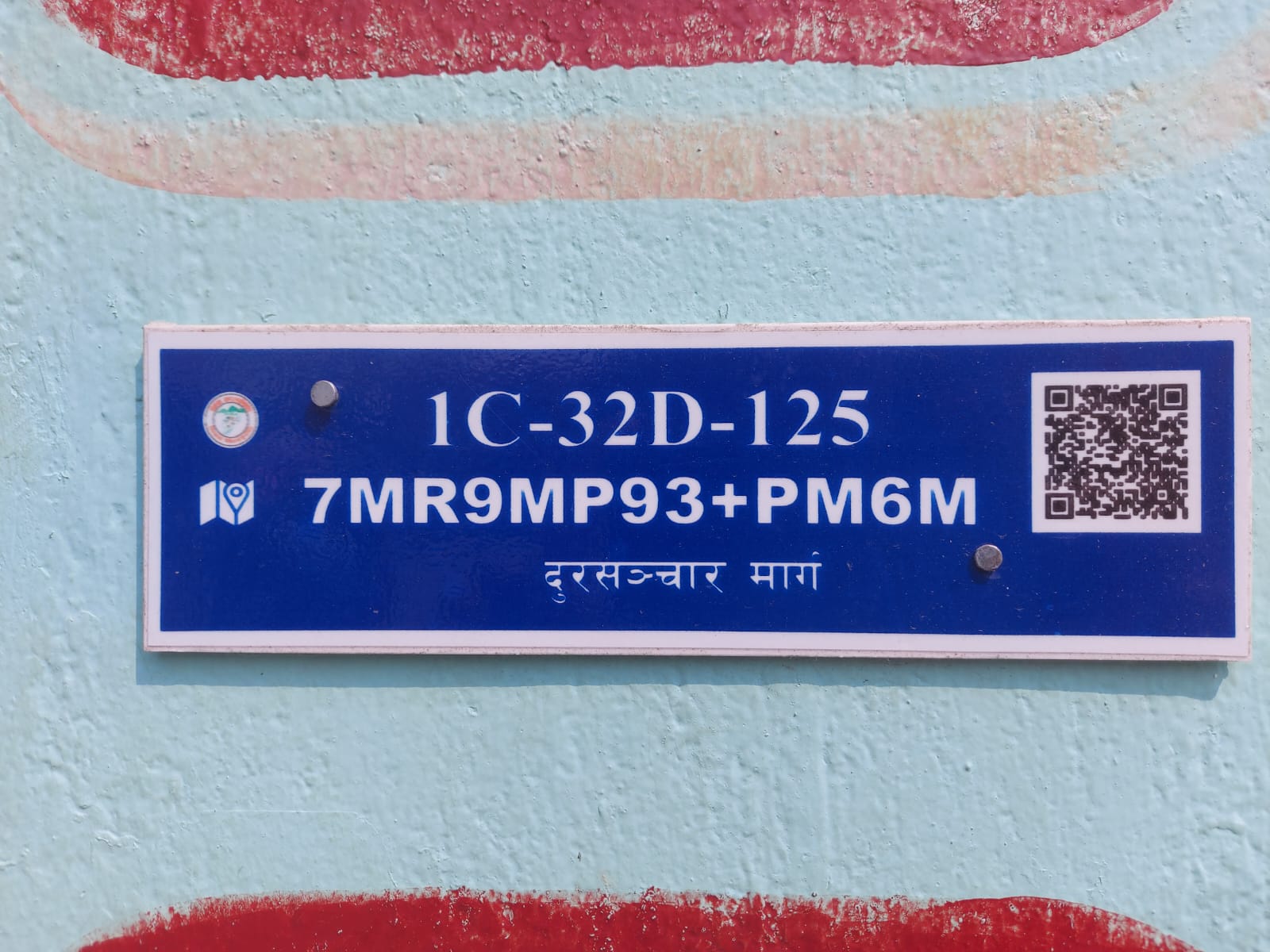
Unlike usual invitation cards QR code and google plus code were also pasted at the invitation card. The card recipients were surprised to see QR coordinated with google plus code. Some got confused. Reason: the invitation cards with QR coordinated with google plus code were extended to them for the first time in their lifetime.
The small but significant change is evolving in eastern Nepal especially in the field of information technology after Damak Municipality takes a lead in this sector. Be it social gathering, marriage ceremony, rice feeding, religious functions and gathering of friend circles or relatives, locals in Damak share QR with google plus code to get the right location. That provides exact location easing arrival of newcomers.
For invitees, QR code directs towards the right location.
“These days, locals have started to share their actual location in invitation cards extended to relatives to participate in any ritual like marriage, rice feeding or social celebration,” says Sameep Chudal, information technology officer at the Damak municipality.
Three years ago, an exemplary digitization drive was initiated by the then Mayor Romnath Oli in Damak. His successor Ram Kumar Thapa also continued the digitization drive considering its impacts in the long run.
“Even as this digitization drive was initiated by previous leadership, I gave continuity thinking it will have impacts in the future. It’s a kind of model project for us,” said Ram Bahadur Thapa, mayor of Damak Municipality.
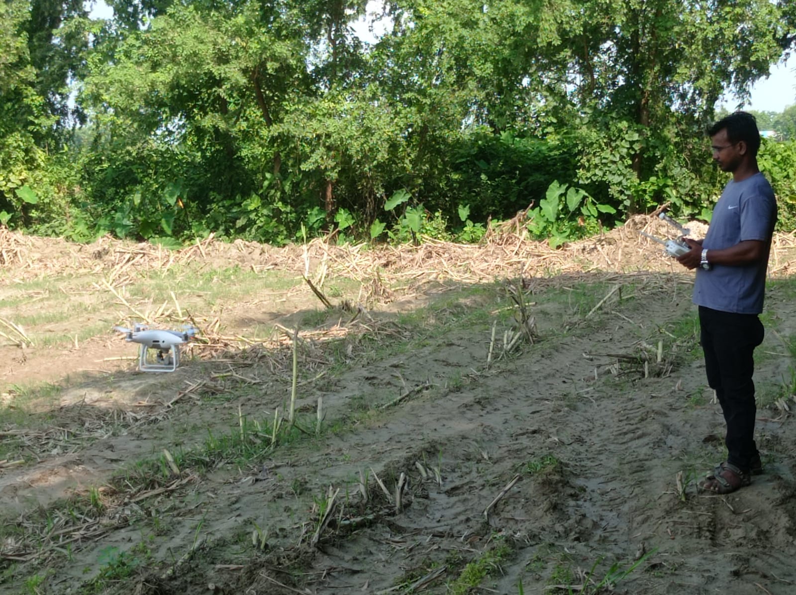
To build digital infrastructures the municipality captured aerial images of the entire municipality area by using drones. It was a kind of one step at a time approach to build digital infrastructure. Based on drone images, the municipality digitally gave numbers to each household. Then, employees conducted a ground survey of households to make sure their numbering system was okay, determined native code of those houses and transformed household details into google plus code.
The native house numbering has already been determined. Yet, to make it universal the municipality has developed QR code which is coordinated with universal google+ code. Once the QR with the google code is shared even strangers can reach the expected destination without any confusion.
“Once you redial google code it is scanned. To make it universal we installed google+ code as well,” said Sameep Chudal, adding, “We have also determined native house numbering.”
Based on drone photos the municipality identified households, coordinated them with technology and native code has been transformed into google plus code.
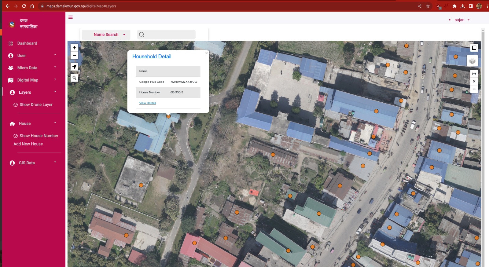
A separate website with orthomosaic images, maps.damakmun.gov.np, has been developed to upload all those drone images and connect them with google code. Their next target is to build essential digital infrastructures, ease service delivery and ensure digital transparency.
With the installation of GIS with drone images, municipal officials need not go to the field if they have to measure width, lengths of road in their area. They can get required measurements without hitting the road. That’s been possible because of web GIS with drone images.
So far, more than 23,000 of the total 25,000 households are coordinated with the google plus code. Some cow sheds were also counted as houses so workers deployed for ground surveys are deployed to avoid duplication and separately mark adjoining houses in city areas. The municipality targets to complete the task of house numbering by the end of this fiscal year.
Along with the manual verification of house numbering the municipality is focused on collecting street details. Although inserting street details was not in their initial planning municipality considered installation of those details as digitization would be incomplete without naming streets. The municipality has started inserting street details but the process hit a snag owing to conflicting views of locals in naming streets.
“Some roads were already named based on old survey data. So, we organized public audits to forge consensus in naming the streets,” said Chudal, “Now, naming the street section is also moving ahead.”
Whatever the progress made so far and data compiled for building digital infrastructure are available on the web portal. Couriers and post offices can use digital data once the project completes. Street databases will also be included in it and publicized once the task is accomplished. This web portal is being upgraded as a GIS portal, wherein the public can see width, setback and length of road, number of electricity poles and transformers among others.
The municipality is working on the Municipal Transport Master Plan. Data related to the transport system will also be attached into this system.
Before initiating the digitization campaign, the government used to prepare study reports for transport reform and dump them somewhere at the office. From now onwards, transport related data such as width and length of road will be made public via the dedicated web portal soon.
Technical glitches
Damak Municipality was one among a few local governments to digitize its service to local people. The online revenue and property collection has now been halted for the time being because of some policy issues. This year, the municipality decided to collect property tax and land revenue tax separately contrary to the previous policy of collecting integrated property tax.
Since the new software isn’t developed as per changed tax provision the municipality is collecting taxes manually. Other services such as housing design approval certificate and recommendation are ensured digitally. Full-fledged digital service will begin once the ongoing digitization project completes.
Once the digitization process comes into full operation designers, technicians and municipalities will be benefited from street details as precise right of way, width, length of each street will be demarcated in the digital maps.
Housing design consulting companies can also use digital maps uploaded by the municipality and digitally submit their proposal on behalf of clients. The municipality can approve designs accordingly after going through physical documents. “Of late, we are working on ‘less paper model’ and will begin paperless work shortly after the system is developed,” said Mayor Thapa.
Digital Bonus
Once their full-fledged digitization drive completes the locals will be largely benefitted from this campaign. Apart from getting the right location courier companies, post offices and companies involved in online business could take advantage of information technology.
The post office is requesting local governments to use google plus code for effective parcel delivery. So is the case of online delivery, municipal officials believe.
“Both post office and online businessmen can use the same google plus code,” said Chudal.
The municipality plans to connect google code with municipality’s software. Once their system is connected with the google plus code, they have developed the municipality to get the exact location of the house, road condition, get idea about rate of taxation around the houses.
Taxation system of the municipality will also be connected online. “We are now building a digital foundation. Tax should be precisely collected,” said Mayor Thapa, “Taxation system will be more transparent, no chance to manipulate local authorities.”
Also, the municipality believes the royalty row with Nepal Electricity Authority is likely to come to an end with compilation of street details. Despite the municipality's decision to collect a tax on electricity poles, the decision hasn’t yet been implemented due to the absence of precise data about electricity poles along the road. Consequently, the municipality itself is in the dark about royalty given to the authority.
Based on the number of electricity poles the municipality is not preparing to take up the royalty issue with the NEA and ISPs.
Till date, 95 percent of house numbering has been completed. The tasks of municipality transport management, street database compilation and cadastral mapping is underway. Once all these tasks are accomplished the full-fledged database will be made public.
Based on cadastral data land ownership certificate of land plot number and land details such as agricultural, residential, industrial areas as categorized in land use policy and drone image will be embedded there.
Local governments are putting their efforts to digitize service delivery and promote good governance after Nepal adopted a three-tier government in 2015. To institutionalize federalism and make service delivery more effective, the Province Level Governance Project (PLGSP) is implemented in all 753 local governments and seven provinces.
Under financial support provided by the Program information technology officers like Chudal are appointed in all local governments. The Program prepares guidelines, trains IT offices and provides technical support leaving local governments to compete among each other for effective service delivery. Consequently, local governments are coming up with various ideas to digitize service delivery apart from building a digital database in their respective offices. Of them, Damak is overhauling traditional bureaucratic works by utilizing information technology.
To reduce telecom expenses and keep record of official telephonic conversation the municipality is using a single telephone from which maximum concurrent intercom calls are arranged within the municipality and all ward offices.
By calculating expenses incurred so far and expenses supposed to complete the remaining digital infrastructures the municipality thinks it will cost about four million.
“Investment in technology is not just for a short span of time,” said Chudal, “It will benefit the service seekers in the long run. Moreover, it will prevent any kind of fraud and transparency will be maintained.”
IT experts see the progress made by Damak is inspiring other local governments leveraging technology to facilitate improvements in local governance and service delivery. This step, while may seem basic at a glance, is a monumental leap towards digitization and efficient governance at the grassroots level.
“The use of Google Map coordinates and drone imagery for mapping and house numbering is not just a foundation for modern civic management; it's a gateway to countless opportunities for further technological integration into everyday life and governance,” said Dibakar Sigdel, a data scientist at University of California, Los Angeles, “This approach lays down the initial layer of a much-needed digital infrastructure in remote areas, serving as a robust platform for future advancements.”
Sigdel believes foundational work is vital for emergency response, urban planning and economic development.
But the municipality says the resource crunch is a major challenge to make digitization drive functionable. As many as 20 percent of new houses are constructed since the municipality conducted a detailed drone and ground survey to digitize houses.
“We need to allocate the budget to complete the project every year,” said Mayor Thapa, seeking additional support from donors, “Making people aware about the importance of information technology, getting their full support in naming streets and houses and uplifting their economic status to ensure use of smartphones and computers are other challenges.”
***
Related
content
content


