
 Locations
This autumn, a community of enthusiasts, cartographers and photographers united around an interesting and important mission – to make the key geospatial data of Cherkasy available to the public, create pedestrian and inclusive navigation aids, and improve information about tourist sights in Cherkasy Oblast through the mapping services OpenStreetMap and Mapillary.
UNDP Ukraine Accelerator Lab, together with the Digital Cherkasy Project Office, with support from the Ministry of Digital Transformation of Ukraine, organized a Mapathon – an interactive event involving citizens in mapping their city and contributing to digital transformation at the local level. The initiative was also supported by Cherkasy City Council and Cherkasy Oblast State Administration.
- Progress of Cherkasy City mapping, November 2021, Fedir Gontsa
During the Mapathon, we saw the map of the oblast being filled with relevant data, and the number of stakeholders and amount of community involvement in the activity is growing. In planning this project, we expected to obtain updated data on pedestrian and inclusive navigation, but we got much more than that:
● A lively community with a supportive atmosphere and experience sharing among participants;
● The city’s first-ever open data set on street lighting, which is easily available for analysis and managerial decision-making;
● The ability to look up wheelchair accessible routes;
● A prototype of a tactile map for people with disabilities printed on 3D printer;
● Strong interest and plans of the city and public authorities to continue implementing the OpenStreetMap for city planning and for the emergency services.
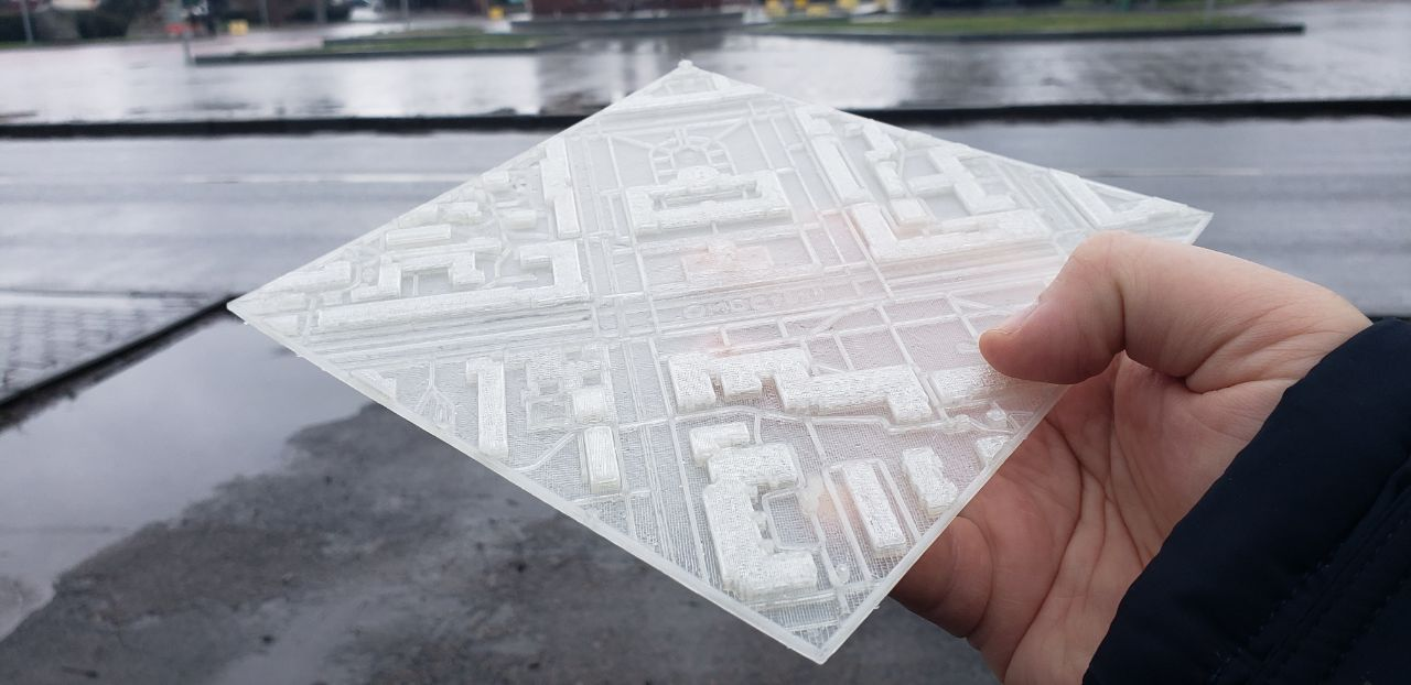
Prototype of a tactile map printed on a 3D printer. Photo: Fedir Gontsa
The map of Cherkasy Oblast has been updated with new buildings, bike lanes, parking lots, sidewalks, ramps, pedestrian crossings, speed bumps and transport stops. All of these have a real impact in improving the lives of Cherkasy citizens and developing the region’s tourism potential.
Here are some of the important numbers from the Mapathon:
● 1,209 points for persons with disabilities added (there were none at the beginning of the Mapathon);
● 419 new pedestrian crossings marked;
● 17,113 elements of street lighting;
● over 146 kilometres of sidewalks mapped.
Quality Leap for Cherkasy
The organizers and participants analysed the results of the Mapathon, and shared new experiences in photography through the Mapillary platform, and in applying geospatial data on OpenStreetMap at the final “Open Mapathon: Digital Cherkasy” meeting held on 29 November. People experienced in mapping as well as newcomers took part in the initiative.
Oleksiy Liuliuk, Mapathon Coordinator, who has a great deal of experience in national and international mapping projects, said: “We, the team of cartographers, do change cities. This month of Open Mapathon: Digital Cherkasy was powerful, for a relatively small team made more than 170,000 edits. These are the incredible results that we achieved together. We can add even more changes. Let’s make our cities and communities better.”
More information about the Mapathon and its results can be found on the wiki page Open Mapathon:Digital Cherkasy.
Fedir Gontsa, OpenStreetMap volunteer and a cartographic designer, explained in detail the Mapathon’s achievements, in particular, the important goal of improving information on accessible pedestrian objects in Cherkasy.
“We now have an inclusive city map, because we have mapped the lowering of sidewalks, curbs, pedestrian infrastructure, and marked the surface types (tactile/non-tactile), as well as various barriers. In fact, now wheelchair accessible routes for people with disabilities can be built in the city. This is the kind of map that needs to be constantly improved, and the Mapathon facilitated this breakthrough. More possibilities are opened with OpenStreetMap, such as tactile maps for people with visual impairments.”
During the final meeting, Serhiy Svierchkov, Deputy Chairman for Digital Development, Digital Transformation and Digitalization of Cherkasy Regional State Administration, thanked all Mapathon participants for their important work and its practical results, which are now open to everyone. The OpenStreetMap community in Ukraine also received thanks from Cherkasy Regional State Administration for the development of tourism infrastructure.
“I’m impressed by the scope of the work that the volunteers have done,” said Pavlo Valenchuk, Deputy Mayor on the Activities of the Executive Authorities. “On behalf of Cherkasy Mayor's office, we are grateful for this, and we are already considering how we can best utilize the results of this work for the good of this city. For example, emergency services can benefit from these inputs to better understand where there is access to buildings, and how to avoid gates. The houses now have a specific geographical references, and there is correct numbering, which is very useful for all services working in the city. You have provided us with an important data set.”
“The Mapathon for us, as organizers, was a total revelation,” noted Ievgen Kylymnyk, Head of Exploration of UNDP Accelerator Lab in Ukraine. “When you engage a lot of people on a pro bono basis, you don’t know what is going to happen. But in fact we got some interesting results that we hadn’t even been expecting.”
“It was nice seeing that owing to the community of people and the use of tools such as Mapillary and OpenStreetMap, better results can be achieved than the work of several task force units,” said Yaroslav Shvydkyi, Chairman of NGO “Digital Cherkasy. “The results of the Mapathon prove that self-organization of people can give a big boost to any processes, including digital transformation in our region, becoming a driver for other changes.”
Active Community and Inclusive Development
Currently, owing to the Mapathon, Cherkasy can be compared with other European cities in the quality and relevance of its data. It is important to unite and implement such initiatives, not only in specific cities but also throughout Ukraine.
The Mapathon was another example of the application of collective intelligence or, more specifically, citizen science, to solving the problems of sustainable development. By combining open geospatial data, community activism and OpenStreetMap, we have shown how a decentralized approach can be applied in practice to address community problems and ensure inclusive development and the implementation of UNDP’s Leave No One Behind core principle in sustainable development through common action.
To date, the volunteer community is actively improving the data on OpenStreetMap, and local governments are considering ways to inform the solutions using it to manage the city, and in planning and improving the tourist experience. The opportunities to use these inputs are countless, and we can see this Mapathon’s achievements being scaled up in the future. To achieve this, interest should be maintained in the community, in particular through creating demand for open geospatial data.


