
 Locations


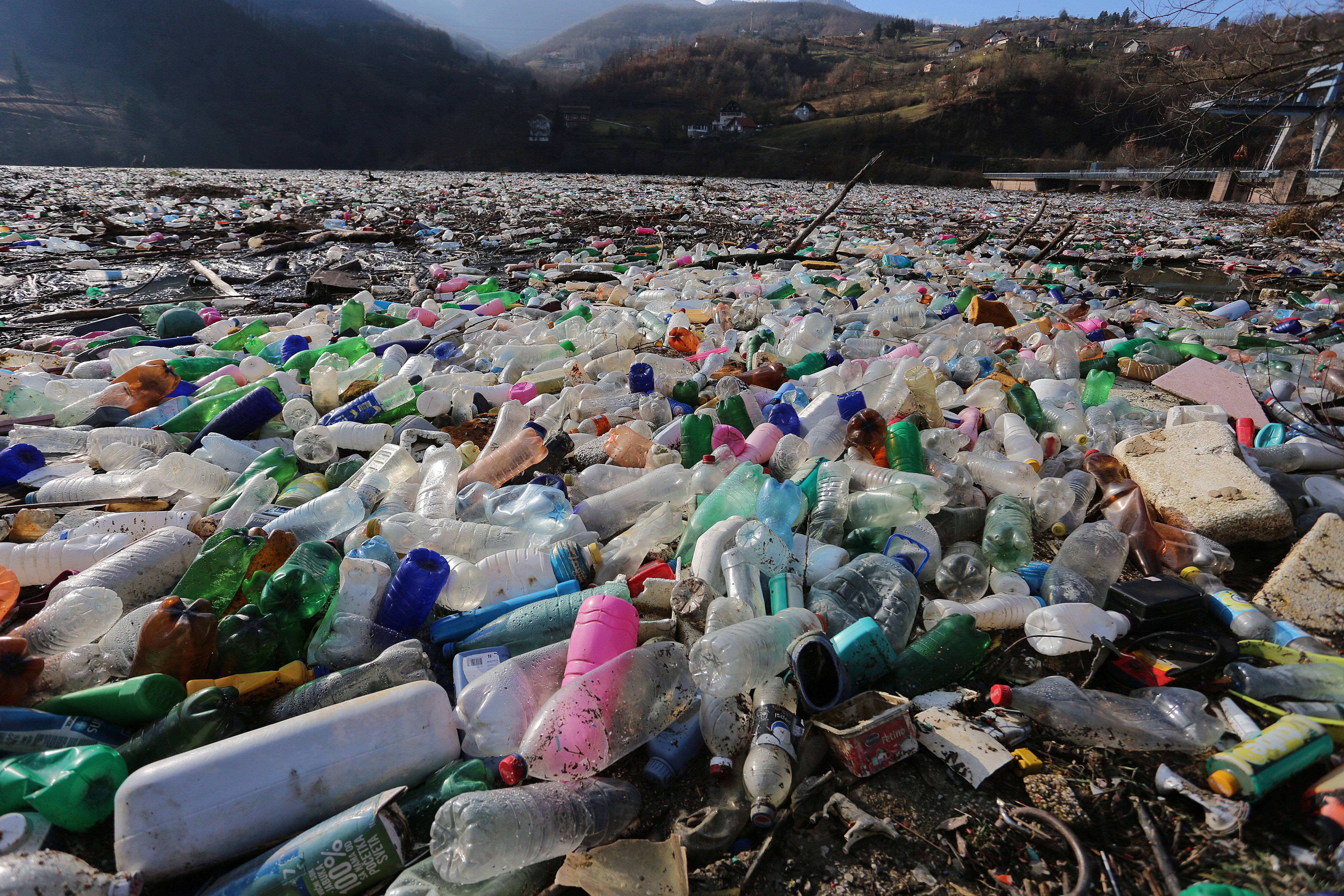
Potpećko Lake, photo: Beta/Dragan Karadarević
Images and photos of thousands of cubic meters of plastic bottles, refrigerators, tires, and other floating waste in the Drina River basin have also overwhelmed all media outlets in Serbia this year. The worst situation was observed on the Lim River near Potpećko Lake, whose area was not visible due to the accumulated waste.
Both organic and non-organic waste in rivers cause a series of severe consequences, primarily to the wildlife and nature, and then to economy. Hazardous substances from waste, particularly heavy metals, destroy wildlife in rivers, and on the top of it, find their way to potable water. Waste deposited on river banks destroy vegetation, which causes intensified bank erosion and increases the risk of flooding. It also jeopardizes the operations of hydropower plant and water intakes of factories for potable water treatment. Accumulated waste in Potpećko Lake jeopardizes the work of the hydropower plant of the same name. Finally, polluted rivers are not attractive for rest and recreation, and negatively affect the development of tourism.
Main culprits for this and similar situations are dump sites discharging waste into the Lim, Drina Rivers and other rivers in Serbia. According to the report of the Environmental Protection Agency (SEPA), there were 2212 wild dump sites in Serbia in 2019. A large number of them was along the watercourses. One third of illegal dump sites registered by SEPA have been cleaned on several occasions, but they are persistently reappearing.
Three neighbouring states, Montenegro, Serbia and Bosnia and Herzegovina, that share the Drina River Basin, formed the expert commission back in 2019 to jointly resolve the problem of waste ending up in rivers. It was agreed that the competent ministries would help local governments in resolving this growing problem.
In search of a solution
In order to help the Ministry of Environmental Protection and other competent institutions in Serbia to find faster and more efficient way to detect less detectable dump sites along the Lim River watercourse, we decided to test a new experimental approach.
The objective was to find whether artificial intelligence (AI) in combination with satellite images, which are broadly available and relatively inexpensive to use, could be used for automatic detection of illegal dump sites. In that case, instead of people spending long hours analysing images and discovering this phenomenon, a software tool would do it for them.
At UNDP, we are in constant search for new technologies and methods, that can help find innovative solutions for such complex challenges. Our Accelerator Lab conducts fast experiments, in order for us to learn all the methods in which we may apply new technologies in practice.
Our idea was to, on a small scale example, explore how to identify sources of pollution in a quite vast area. The growing amount of waste generated by humans and its disposal is a global environmental problem. Finding an efficient method for dump site detection would help Serbia to resolve this problem, but could also be applied in other places to resolve the similar issues worldwide.
We have therefore decided to try to map all dump sites along the Lim River watercourse throughout Serbia, in the length of about 100 kilometres. This experiment was supported by a strategic UNDP partner, European Space Agency (ESA). With their help, we obtained satellite images of the Lim River watercourse through Serbia, and ESA also hired experts who provided us with computer resources for data processing, provided expert assistance in the development of artificial intelligence models and in interpreting the results of the experiment.
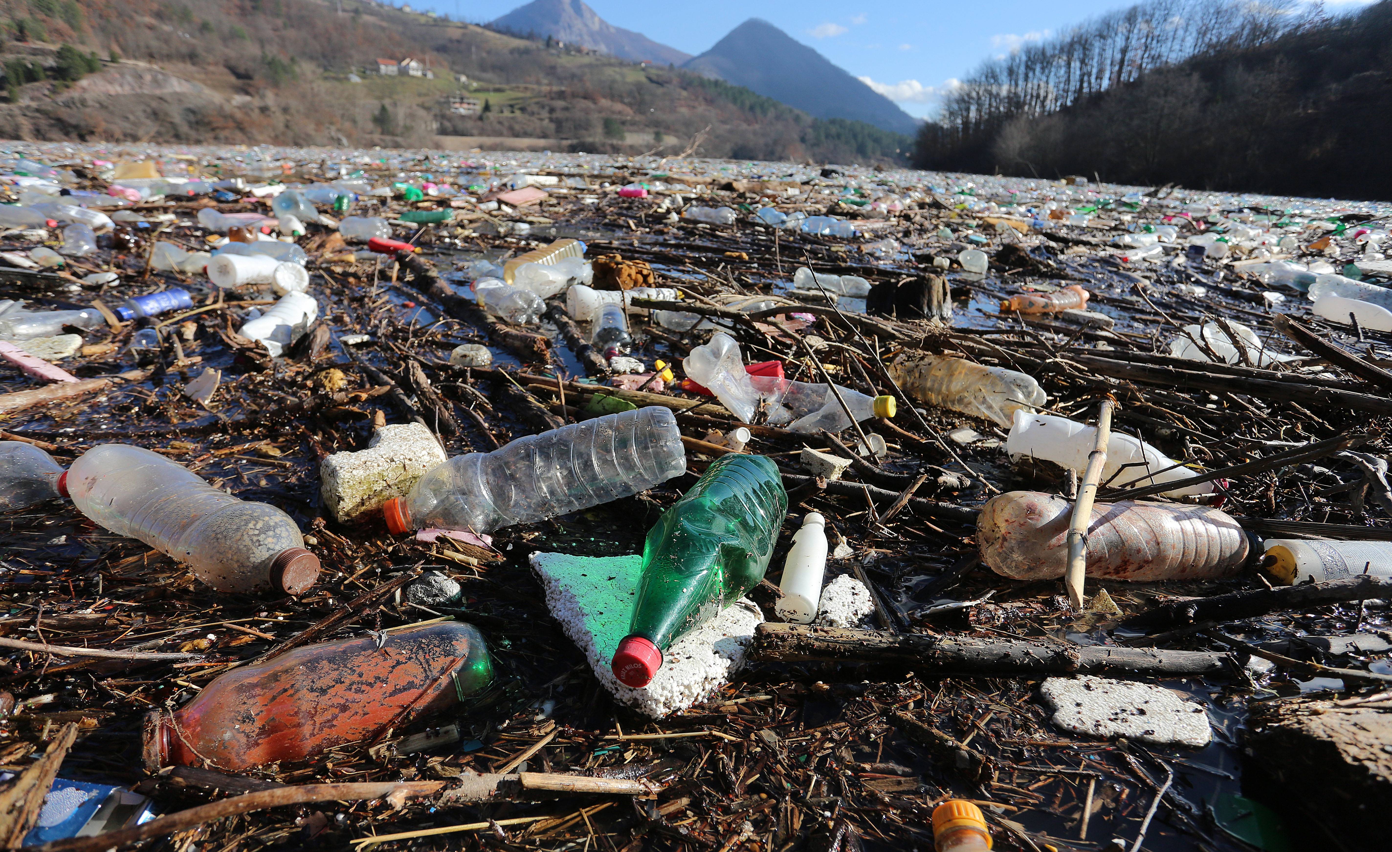
Potpećko Lake, photo: Beta/Dragan Karadarević
How did our artificial “brain” work?
To put it simply, our task was to “teach” a computer programme to recognise similar formations in other images based on existing satellite and aerial (orthophoto) images of dump sites. This approach, called supervised machine learning, first involved getting the data about geographic locations of known dump sites and images of these locations. We also needed the most recent satellite images of the watercourse of the Lim River throughout Serbia we would use to apply the “learnt” model of artificial intelligence and try to discover locations of wild dump sites.
For the purpose of this experiment, we downloaded data on 150 legal and 3350 illegal dump sites in Serbia from the Environmental Protection Agency (SEPA) Also, thanks to the Ministry of Environmental Protection, we received images of the Republic Geodetic Authority for the period from 2007 through 2013, when the highest number of data points on dump sites was collected. Out of that, we selected almost 500 high-quality images of confirmed dump sites, which served us to “study” the model of artificial intelligence.
When the model was ready, we tried to use it to identify dump sites on adequate satellite images of the watercourse of the Lim River in Serbia. At the time of the experiment, the most recent cloudless images were the ones made by Pléiades satellite in the course of the second half of 2019, with the resolution of 50 cm (1 dot on the screen represents 50 cm in nature).
Our model detected 1443 areas that could be dump sites on these images. Experts engaged by ESA visually verified these areas and narrowed down the choice to 61 potential dump site locations. That is a significant increase compared to 23 that SEPA recorded 7-8 years ago. We shared these data with officials of the Ministry of Environmental Protection and the Municipality of Priboj, the biggest settlement along the Lim River Basin in Serbia, to be subject to field checks in the coming period as a part of broader efforts to resolve pollution problems in the Lim River basin.
What have we learned out of the experiment?
Since our AI model did not show a high level of accuracy in automatic dump site detection, we were unable to prove the initial assumption. As a reminder, the assumption was that satellite imagery could be used for fast and automated landfill sites mapping by using AI.
What was missing? Supervised machine learning models require a large amount of input data. In our case, we had at our disposal a very small number of already confirmed dump sites in the Lim River basin (only 23 in the SEPA data set), so we had to train the model using the examples of confirmed dump sites in other parts of Serbia. However, it turned out that even over 400 additional images of the confirmed dump sites did not represent a sufficient-size sample. Namely, when observing a large geographical area, dump sites are relatively rare and small in area. In addition, they are visually similar to some other phenomena such as bare land, piles of bulk construction material on construction sites or certain types of goods in warehouses.
In order to increase the accuracy of the model, it would have to be pre-trained with a larger number of images of confirmed dump sites, as well as to use images of much higher resolution - at least 30 cm, and preferably 20 cm or even better. The accuracy of the model could be improved by applying additional techniques. For example, based on the assumption that illegal dump sites appear near transport corridors, we could take data on the network of streets, local and regional roads in Serbia, and exclude from the search area all areas that are, for instance, more than a few tens of meters away from some road.
Although the fulfilment of these requirements is not impossible, it however requires significantly increased resources. Higher resolution satellite or aerial imagery is still quite expensive and would require far more storage space and computer processing power, so the question of the cost-effectiveness of such an approach could be raised, at least at this point in time.
The encouraging thing is that the trends are in our favour - in recent years we have witnessed very rapid development of space and cloud technologies, as well as of artificial intelligence. Satellite launches and increasingly powerful computing resources are becoming more accessible, so it is quite possible that we will have the conditions to revise this experiment, with a much more precise end result in the foreseeable future.
We also hope that our example of the application of machine learning technologies to solve environmental problems will inspire others to explore, and thus contribute to faster improvement of the method and its use on a wider scale.
***
A detailed technical report on the experiments is available on the website of the European Space Agency.
****
Blog was originally published on Business Intelligence Review.


