
 Locations
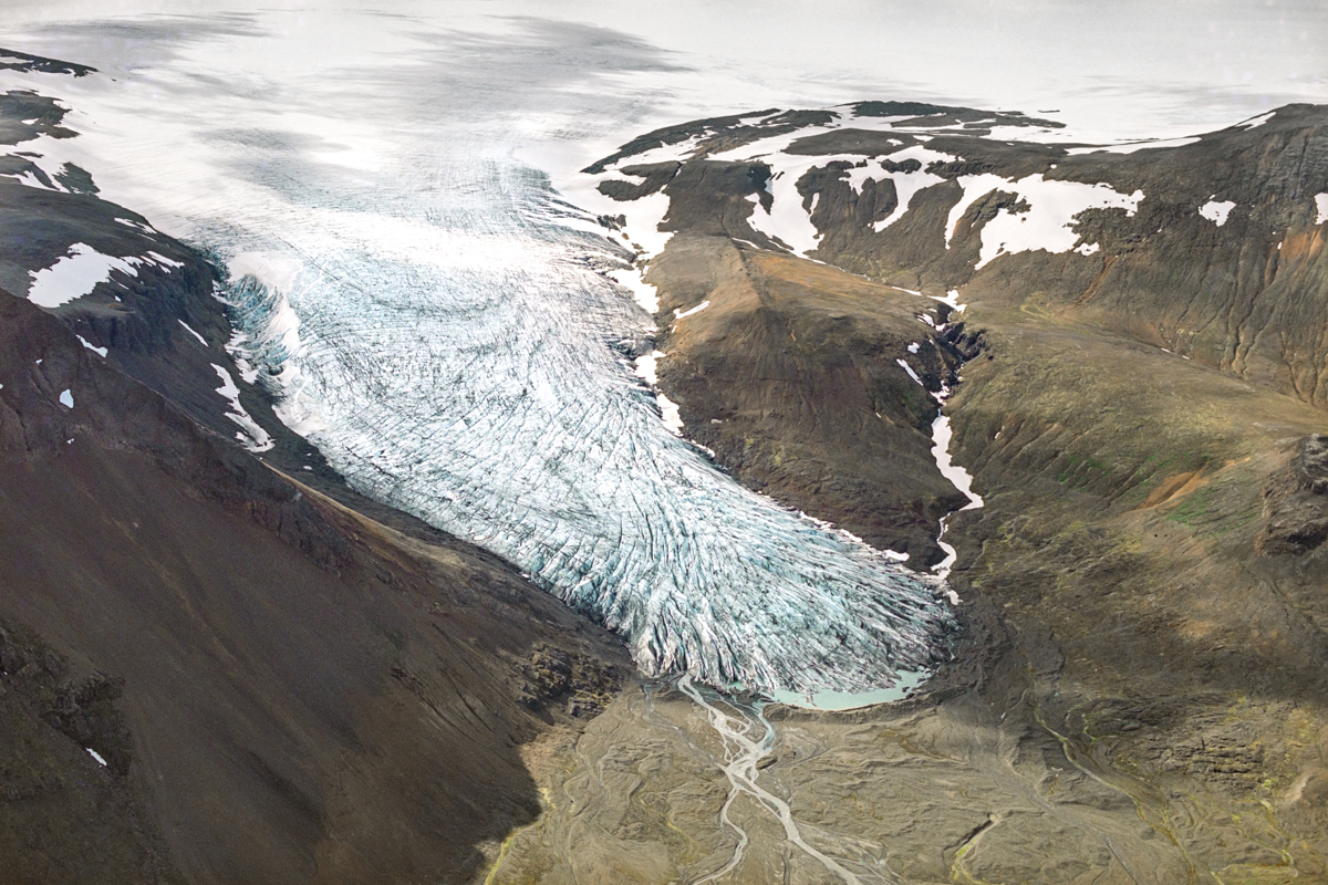
To draw public attention to melting glaciers and climate change within the framework of the Political Action for Climate Security in Central Asia project, funded by the Government of Great Britain and implemented by UNDP in Kyrgyzstan, Tajikistan and Uzbekistan, the Central Asian Institute for Applied Geosciences (CAIAG) provided images of glaciers to organize the "Dance of Melting Glaciers" photo exhibition in light of the upcoming 26th Conference of the Parties (COP 26) by UN Framework Convention on Climate Change (UNFCCC).
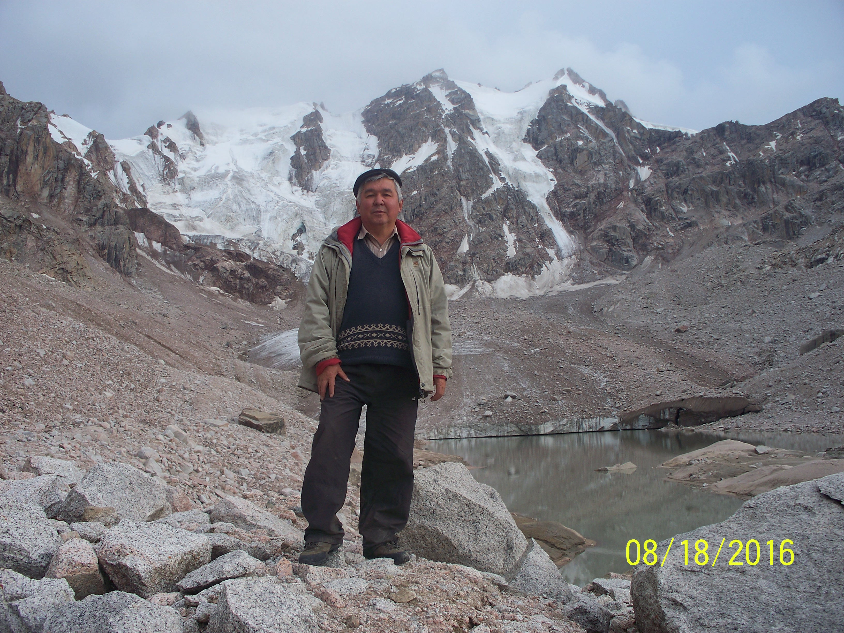
In addition, within the framework of the above project, the Azattyk team of journalists and I visited several glaciers in Kyrgyzstan, where they are constantly monitoring the melting state of glaciers. A documentary film about the state of glaciers in Kyrgyzstan was filmed, which explains the urgency of glacier melting problem. Meetings with the local population were organized and their point of view was heard regarding the lack of water in the regions in general and the disappearance of glaciers as an important source of water in the summer. The conversation was mainly about the glaciers of Kyrgyzstan, its melting due to modern climatic changes and their role in people's lives.
For example, Kyrgyzstan is one of the largest regions in Central Asia, characterized by prominent glaciers and mountains throughout the country. Within its territory are parts of mountain systems such as the Tien Shan and Pamir-Alai. There are foci of modern glaciation in almost all mountain ranges of the country. The glaciers mountain ranges of Kyrgyzstan are not only an element of the landscape, but also significant moisture preservatories. The snow and ice stored is used in the warm seasons. The role of glaciers increases in particularly dryer years during which glaciers become the only sources for rivers, thereby providing water resources to the nearby valleys and plains.
Tien Shan. On the mountain ranges of the Tien Shan, glaciers of almost all known types are widespread, characteristic of mountain systems of inland regions of temperate latitudes - from small firn-ice formations with an area of less than 0.1 km2 to complex valley glaciers. Such variety is explained by the heterogeneity in the structure of the hypsometry and climatic conditions of our mountainous country. The most widespread glaciers are valley, tar and hanging glaciers. Moreover, in the conditions of decreasing glaciers, the most developed are tar and hanging types. Together with numerous snowfields, these two types of glaciers, concentrated in the near-ridge parts of mountains, create a general background for the glaciation of the Tien Shan. Nevertheless, the basis of the modern glaciation of the Tien Shan is made up of valley glaciers, and not the numerous hanging, crust glaciers and their various transitional forms, which create the general appearance of the glaciation of the Tien Shan. But, despite the fact that the glaciers of the valleys form the basis of the modern glaciation of the Tien Shan, their distribution over the mountain ranges and water basins is rather uneven. If in the basin of the Chatkala river they account for about half of the area of glaciation, then in the basins of the Sary-Jaza and Ak-Sai rivers, respectively, 81.8 and 93.0%.
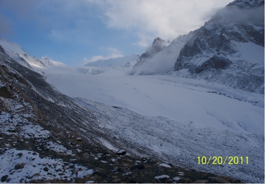
Valley glacier Golubin (northern slope of the Kyrgyz Ala-Too ridge), October 2011
In Kyrgyzstan, so-called flat-topped glaciers are very widely represented, which by origin have their own characteristics and are not found in all regions of the Tien Shan. They cover the leveled sloping surfaces of individual peaks and watersheds and are characterized by high occurrence. The ends of the glaciers do not drop below 4000-4200m, and usually end with a steep cliff and one or two short outlet tongues descending along the hollows of the slope. Most of the glacier is characterized by slight slopes of the surface, which predetermine low ice velocities. There are no moraines on their surface. There are especially many flat glaciers on the southern slope of the Teskey Ala-Too ridge.
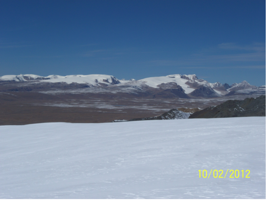
Glaciers of the flat tops of the southern slope of the ridge. Teskey Ala-Too, October 2012
But, due to their small number, in comparison with other types of glaciers, they constitute an insignificant part of the total number of glaciers. For Sary-Jaz, flat-topped glaciers are 2.2% of the total number of glaciers and only 0.8% of the total glacier area. For Issyk-Kol the numbers are respectively 1.0% and 0.6%.
If we talk about the size of glaciers, the Tien Shan glaciers of varying sizes, both in terms area and length. There are glaciers with an area of less than 0.1 km2, and several tens and hundreds of km2. Some glaciers stretch for 200-700 m while others tens of kilometers. Despite the significant area of glaciation, its spatial distribution across the Tien Shan is extremely uneven.
Pamir-Alai. Only part of the Pamir-Alai belongs to Kyrgyzstan. They are the northern slope of Turkestan, the northern and southern slopes of the Alai ridge of the Gissar-Alai, as well as the northern slope of the Chon-Alai ridge of the Pamir. The Chon-Alai ridge covers the Alai valley from the south with a solid monolithic wall. The highest point of the ridge, Lenin Peak (7134 m), is also located here. Almost all types of mountain glaciers are found in the Pamir-Alai, as well as in the Tien Shan. Among them, of course, stands out the northern slope of the Chon-Alai ridge and is the largest focus of modern glaciation in Kyrgyzstan. In particular, the central part of the Chon-Alai ridge has a huge glaciated area of 379 km2.
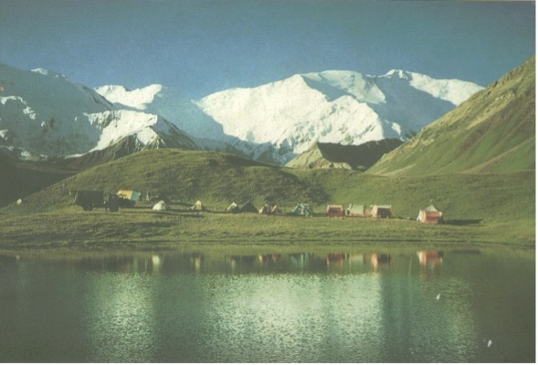
Lenin Peak. View from the Alai Valley, July 1996
The current ongoing global warming is leading to a steady decline of glaciers. At the same time, atmospheric precipitation is one of the most variable elements of the climate. Despite the fact that in the area of glaciers atmospheric precipitation drops 2-3 times more than in the underlying zones, the melting of glaciers continues intensively. Currently, the increase in temperature noticeably affects the glaciers - especially in the discharge part, which leads to a significant reduction in the size of glaciers. The size of glaciers is rapidly decreasing not only in length and area, but also thinning of glaciers from the surface occurs.
Thus, the most objective indicator of the state of glaciers and their evolution is long-term data on the mass balance of glaciers. Continuous annual measurements of the mass balance of glaciers have been carried out on only few of the glaciers in Kyrgyzstan. They include Kara-Batkak, Glubina, Abramova, Western Seuk, No. 354, etc. The balance of the mass of glaciers in most cases is negative. The rare positive mass balance of glaciers is associated with precipitation above average levels. Therefore, the degradation of glaciers increases, and they retreat with varying intensity, which leads to a significant reduction in the size of glaciers. Lakes of glacial origin are often formed at the end of retreating glaciers.
Glacier with glacial lake in the Chychkan river basin, Issyk-Kul basin.
It is also worth noting that in 2018 we completed an inventory of glaciers in Kyrgyzstan based on satellite images. In total, according to Landsat-8 satellite images as of 2013-2016, there are 9,959 glaciers on the territory of Kyrgyzstan with a total area of 6683.9 km2, including: 6,227 glaciers larger than 0.1 km2, with a total area of 6494.0 km2 and 3,732 glaciers less than 0.1 km2 in size, with a total area of 189.9 km2. According to the Catalog of Glaciers of the USSR (1940-1970), on the territory of Kyrgyzstan, there were 8,164 glaciers with a total area of 7944.2 km2, including: 6,719 glaciers larger than 0.1 km2, with a total area of 7866.6 km2 and 1,445 glaciers less than 0.1 km2 in size, with a total area of 77.6 km2. The total number of glaciers has increased by 22%. This is due to an increase in the number of small glaciers (less than 0.1 km2) by two and a half times (258%), while the number of large glaciers (larger than 0.1 km2) has decreased by 7.5%. Information on glacier reduction and modern distribution in the main river basins of Kyrgyzstan is presented below.
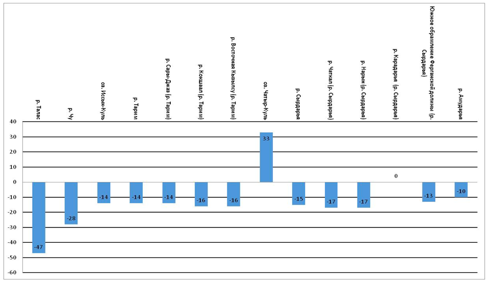
Reduction of glacier area in the main river basins of Kyrgyzstan from 1940 to now
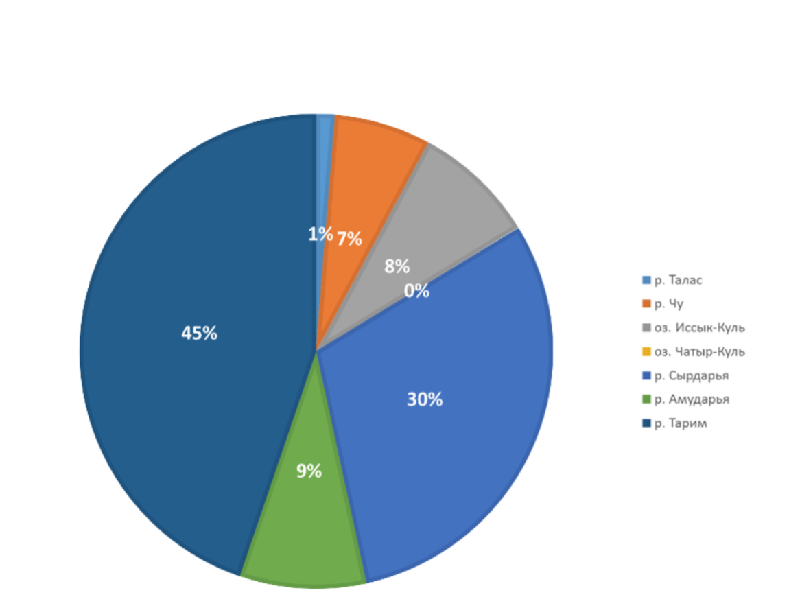
Modern distribution of glacier areas
Reduction of the areas of the main part of glaciers in Kyrgyzstan is within 13-17%. The exceptions are: Talas, where the area is reduced by 47%; Chu - 28%; Amu Darya - 10%; Karadarya - no change; Chatyr-Kul - stable (there are a total of 9 glaciers with a total area of 3.2 km2). As seen in the diagram, almost half of the glaciation occurs in the river basin. Tarim (45%) and the third part for the basin of the river, Syrdarya (30%).
Thus, over a 70-year period, the following changes have occurred in the general glaciation of Kyrgyzstan. The area of glaciers has decreased by 16%, while the area of large glaciers has decreased by 17%, and the area of small glaciers has increased by two and a half times (245%). This is due to the general degradation of glaciers, in which the degradation of large glaciers leads not only to a decrease in their areas, but also to their disintegration into separate parts, which function as independent small glaciers. In addition, in some parts of the Catalog of Glaciers of the USSR, glaciers with sizes less than 0.1 km2 are not included at all, and this catalog includes all glaciers larger than 0.01 km2 each.
In conclusion, we note the following: according to the Catalog of Glaciers of the USSR (based on aerial photographs during 1940-1970), there were 8,164 glaciers in Kyrgyzstan with a total area of 7944.2 km2. This is almost 4% of the total area of the country. And as of 2013-2016, according to the satellite images "Landsat-8", there are 9,959 glaciers with a total area of 6683.9 km2, which is 3.345% of the total area of the country. Thus, the overall reduction in the territory covered by glaciers is 0.66%.
Author: Usubaliev Ryskul Abdyzhakypovich, Candidate of Geographical Sciences, CAIAG
Edited by Ainagul Abdrakhmanova


