
 Locations
Data and Informed Decisions: The Role of Evidence in Sustainable Metropolitan Planning
28 de Marzo de 2023

Currently, cities face significant challenges regarding their sustainable development and growth. To address these issues, evidence-based metropolitan planning with technology and data has become vital for making informed and strategic decisions. In this sense, smart metropolitan planning emerges as an innovative solution by the Autonomous Departmental Government of Santa Cruz that seeks to improve the future of cities using technology and data. In this blog, we will explore how evidence-based metropolitan planning can drive sustainable urban development, improve the quality of life of inhabitants, and promote equity in the cities of the future in the Santa Cruz metropolis.
Evidence-based metropolitan planning refers to collecting, analyzing, and using data and evidence to make informed decisions in urban development. This involves collecting accurate and up-to-date information on various relevant aspects of cities, including demographics, socioeconomic factors, infrastructure, and environmental impacts.
Data can be collected through various sources, such as digital surveys, administrative records, remote sensors, satellite images, and Geographic Information Systems (GIS). Once collected, data must be processed and analyzed to identify patterns and trends.
The use of evidence in decision-making helps identify problems and opportunities, evaluate the effectiveness of existing policies and programs, and develop new strategies and innovative solutions. In addition, evidence can also help improve transparency and accountability in the decision-making process.
It is important to emphasize that evidence-based metropolitan planning should be a continuous and adaptable process as urban conditions change and new data and evidence are obtained. Therefore, the Autonomous Departmental Government of Santa Cruz has implemented an effective strategy to improve the quality of life in cities.
The Autonomous Departmental Government of Santa Cruz GADSC has adopted an innovative methodology for evidence-based metropolitan planning. This new planning methodology has been designed to improve strategic decision-making in the metropolitan area by incorporating empirical data and advanced analytical tools.
To implement this methodology, an interdisciplinary work team has been established, made up of experts in different areas of knowledge such as urban planning, transportation, environment, economy, and data analysis, among others. This team collected, analyzed, and visualized the information necessary for making informed and evidence-based decisions.
This innovative planning methodology represents a significant advance in public management since it allows greater efficiency in resource allocation and greater effectiveness in achieving strategic objectives for metropolitan development by creating the Metropolitan Observatory of Santa Cruz OMSC.
The Metropolitan Observatory of Santa Cruz is a crucial tool that allows the visualization and analysis of critical georeferenced information for planning grey routes in urban and rural areas. Its intuitive and visual interface contains relevant information that allows decisions supported by reliable data.
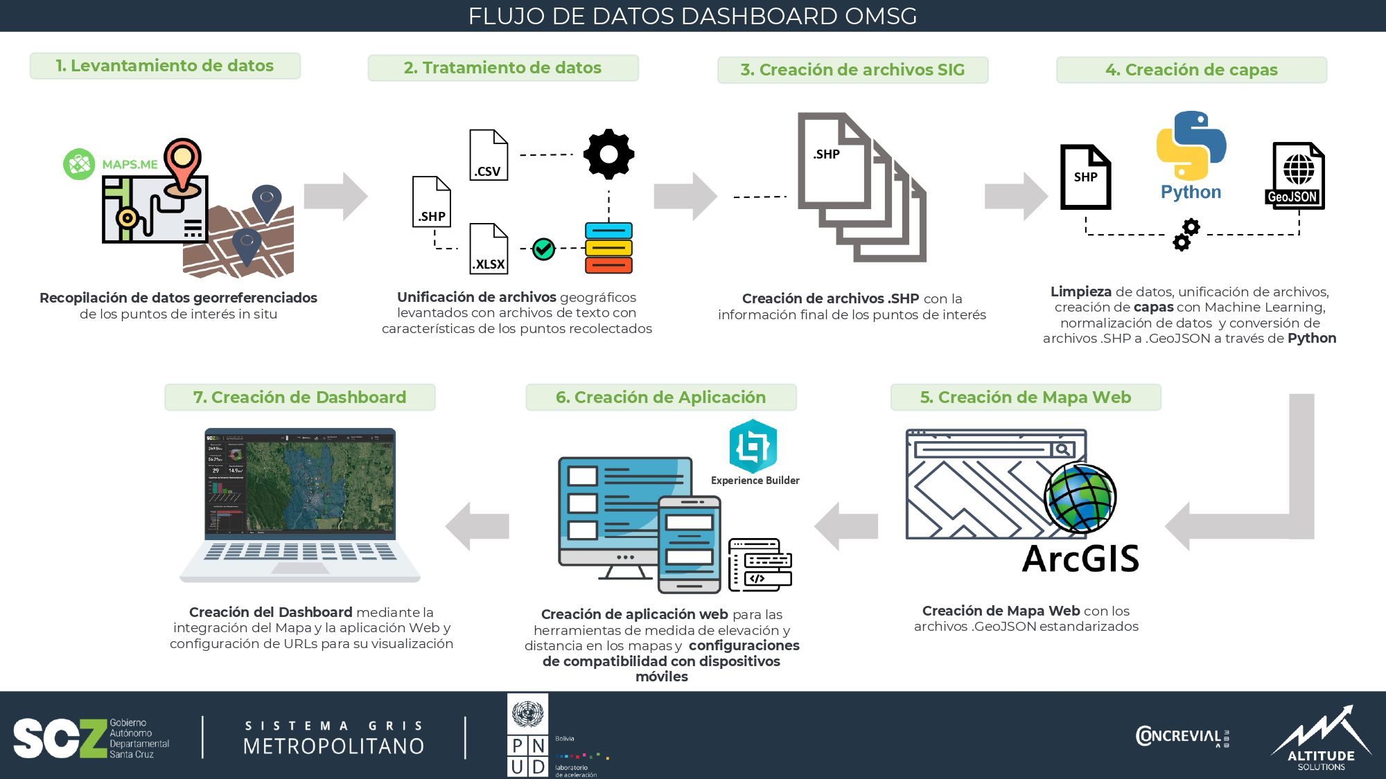
To maximize the efficiency of the Observatory, it is essential to have accurate and reliable data. The geo-referenced data collection was carried out in situ to accurately ensure the location of the points of interest. For this process, the Maps.me the application was used, which allowed the geographical position of the place where the data was collected, and maps were loaded even without an internet connection.
Once the data was collected, geographic information was compiled, and compatible files were generated to visualize this information. The next stage was cleansing, standardization, and creating relationships between different data types, using specialized libraries for geographic data analysis, such as GeoPandas and Shapely. Artificial intelligence algorithms were used for the generation of clean map layers. Finally, with the QGIS program, data validation was carried out, which allowed ensuring the quality of the generated information.
For the design of the OMSG Panel, it was essential to select the most relevant indicators for decision-making and metropolitan planning. In this sense, carefully selecting indicators and graphics were carried out to optimize the panel's visualization and improve the user experience. The data was segmented into eight main layers that allow for better information visualization and facilitate identifying relevant patterns and trends for urban planning.
· Municipalities · Sections · Incidence points of infrastructure (intersections, high voltage tower, sewer, etc.) · Infrastructure incidence lines (gas pipeline, power line, drainage canal, etc.) · Bridges · Critical environmental points · Environmental impact surfaces · Socioeconomic points
To create an effective tool, it is necessary to have a platform that allows storing and managing geospatial data efficiently and generating necessary visualizations. The Dashboard was developed in ArcGIS Online, a platform that allows hosting layers, creating Dashboards, and creating applications accessible from anywhere via the web.


The geospatial data visualization Dashboard for the Santa Cruz Metropolitan Observatory is a valuable tool for urban planning in the metropolitan area. Its implementation allows for the collection and analysis of relevant data, the selection of appropriate indicators, the design of interactive maps and graphics, and the integration with other urban planning tools. All of these, contributes to improving urban mobility and sustainable environments in cities, enabling a better quality of life for their inhabitants.
Evidence-based metropolitan planning is highly valuable for making informed and strategic decisions in sustainable urban development. Data can help local and departmental governments, as well as urban planners, identify and address key challenges in cities, improve crisis response capacity, and promote urban equity. However, it is important to use data ethically and consider the impact of decisions on all communities.
Lessons learned
The importance of data collection and analysis: Data collection is fundamental for informed decision-making. Data can provide valuable information about the needs and preferences of the community, as well as the challenges and opportunities faced by a metropolitan region. Careful analysis of this data can help decision-makers identify effective and sustainable solutions.
The need to involve the community: Sustainable metropolitan planning should be a participatory process that involves the community. Active citizen participation can help ensure that decisions are made with a complete understanding of the needs and expectations of the community and can help generate greater support for the decisions made.
More blogs


