
 Locations
The Geography of Exclusion: The Dynamics of State Discontinuity Across the Territory in LAC
April 22, 2019

One of the ways in which inequality manifests itself is by making location a constraint to socioeconomic achievement. Equality of opportunity implies that the place where a person is born –or chooses to live-- should not determine their access to opportunities or ability to live a decent life. While we tend to measure many indicators of prosperity at the national level, these statistics obscure many of the important inequalities that exist within countries. Indeed, as Bourguignon (2016) and others have shown—while global inequality and inequality between countries has been declining since the 1980s, inequality within countries has been on the rise. To what extent do these within-country inequalities are reflected throughout the territory? More important, what do they imply in terms of policy challenges and governance deficits?
While many traditional measures of territorial inequalities look at disparities in GDP, it is important think about how spatial disparities are manifested beyond income. Perhaps more relevant than inequalities in GDP per capita are inequalities in the provision of public goods and services. In developed countries, as you travel through long distances, you observe a very diverse profile of economic activity, but a rather even quality in terms of the supply and access to public services. In developing countries, the landscape as you travel shows a very homogeneous profile of economic activity –lack of diversification—and a very heterogeneous quality and access to publicly provided services, starting from infrastructure. Following O’Donnell (2010), the state should act as focal point of collective identity and should be equally responsive to the needs of all citizens, regardless of where they live within the territory. Unfortunately, the State presence tends to be discontinuous across space. The State and its effectiveness in providing public services is often unevenly distributed—leaving many regions systematically neglected, and their populations excluded. The State is, indeed, “discontinuous.” Ceriani and Lopez-Calva (forthcoming) provide a way to measure how these “discontinuities of the state” manifest along multiple dimensions—and cumulatively describe the “density” of the state over space.
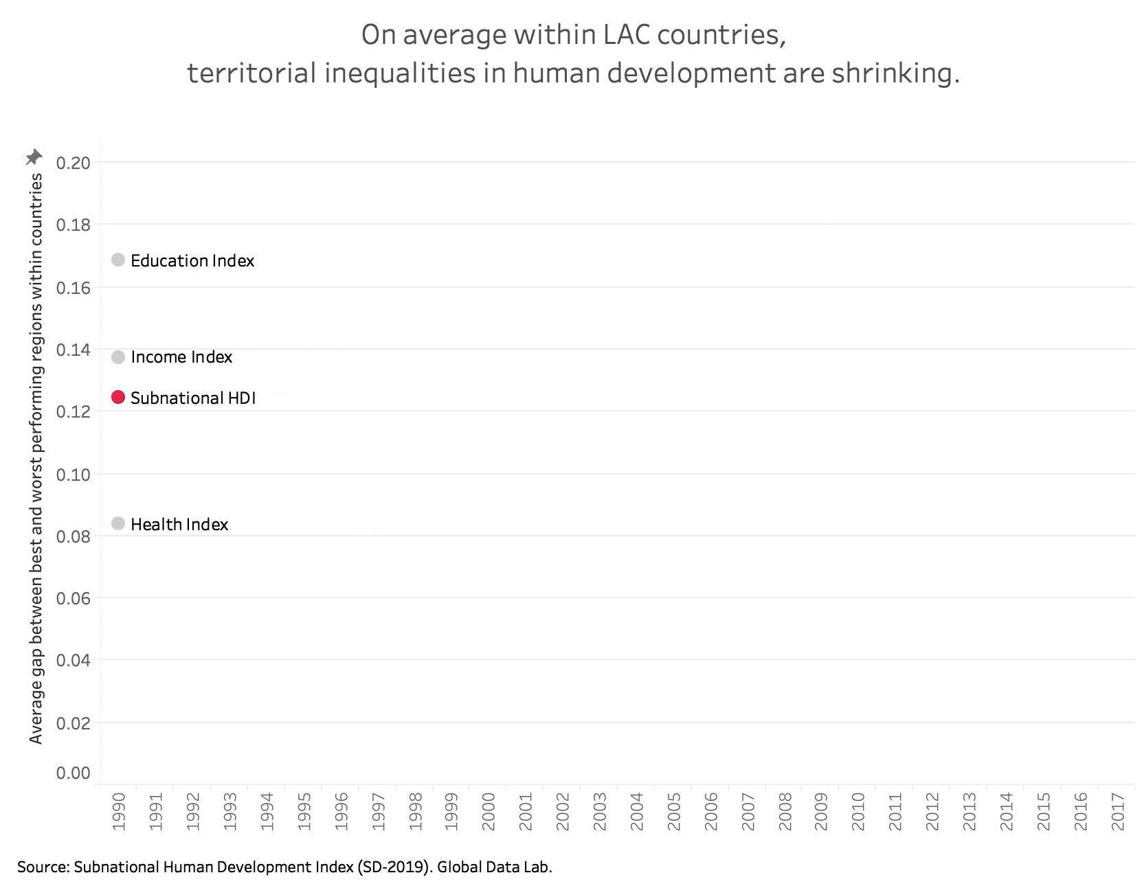
As a means of illustration, using data from the recently updated Subnational Human Development Index (SHDI), this #Graph4Thought shows how territorial inequalities in human development have changed over the period 1990-2017 in Latin America and the Caribbean. Like the national Human Development Index (HDI), the SHDI index combines measures of education, health, and income. In order to measure territorial inequalities, we use a simple measure of the gap between the best performing region in a country (sub-national index closest to 1—i.e. “highest” state presence as measured by outcome) and the worst performing region in that same country (sub-national index closest to 0—i.e. “lowest” presence).
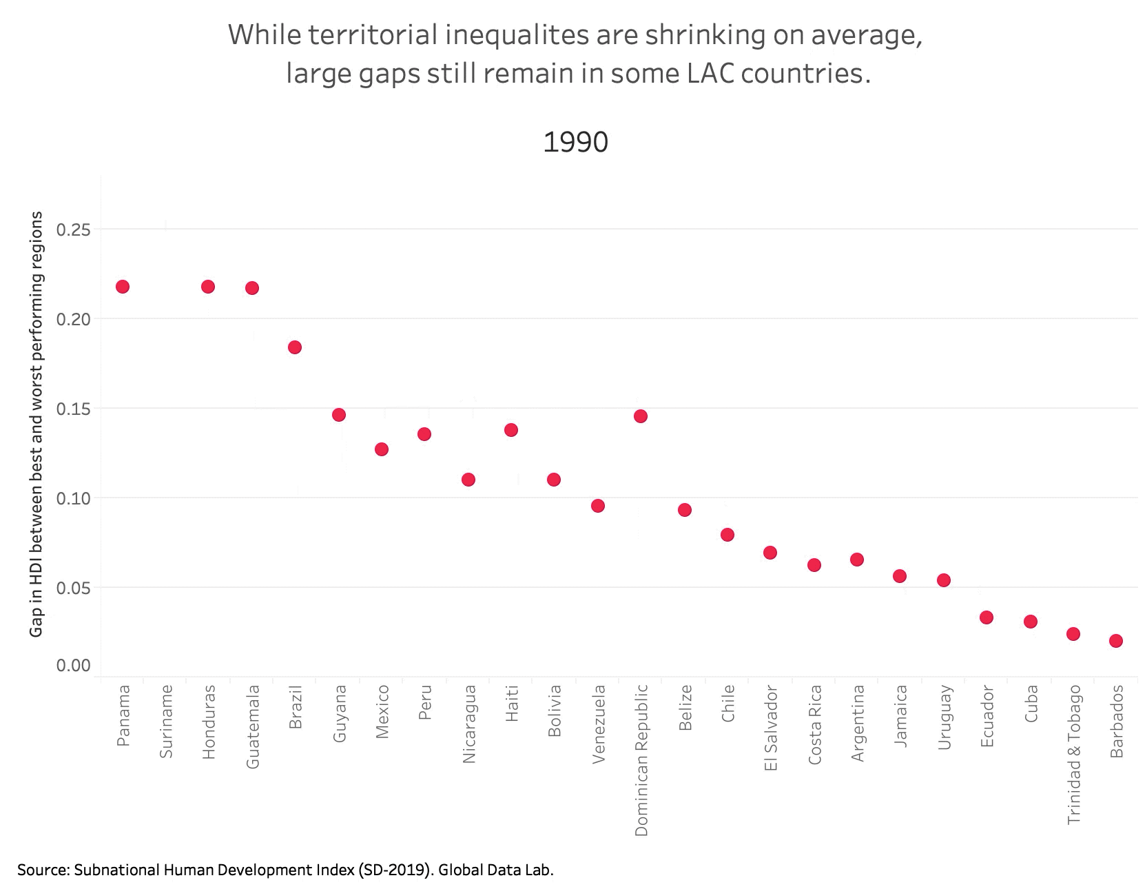
If we zoom in at the country level, we can see a more nuanced picture of what is happening within individual LAC countries. As the pink dots move upwards, we see territorial inequalities increasing. This is the case in countries such as Nicaragua, Bolivia, Venezuela, Belize, and Ecuador. As the pink dots move downwards, we see territorial inequalities decreasing. Particularly large reductions have taken place in countries such as Honduras, Brazil, Haiti, and the Domican Republic. Overall, we see that while territorial inequalities have been shrinking on average, progress has been uneven and large gaps still remain in many countries. For example, as of 2017 countries such as Panama, Suriname, Honduras, and Guatemala still have gaps larger than 0.166 (on a scale from 0-1)—meaning that the level of human development in the best performing region in the country is at least 16.6 percentage points higher than the level of human development in the worst performing region in the country.
Territorial exclusion is an important sign of governance deficits. Additionally, territorial disparities are typically associated with other dimensions of exclusion. Territorial targeting could be, for certain interventions, a way to address multidimensional gaps in a cost-effective way. By understanding how state density differs across a nation’s territory we can gain a better understanding of how and where people are being left behind. A territorial approach to the 2030 agenda is important not only for ensuring economic inclusion, but also for enhancing the social and political cohesiveness of society. As Kanbur and Venables (2005) observe, spatial inequality “has added significance when spatial and regional divisions align with political and ethnic tensions to undermine social and political stability.”