Data-Driven Approach in Flood Mitigation: From Physical to Digital Infrastructure (Part 2)
May 30, 2023
With Ajeng Larasati - Innovation Officer, UNDP Accelerator Lab Indonesia
Edited by Ranjit Jose

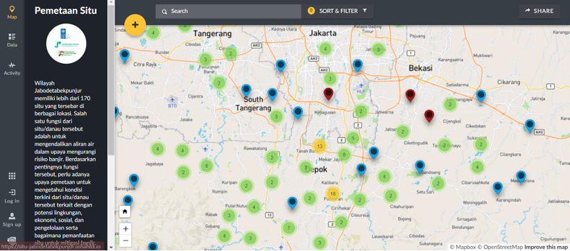
Figure 1. Dynamic map of natural and artificial lakes as part of flood mitigation infrastructure in Jabodetabekpunjur
In disaster-stricken regions around the world, access to updated information about conditions on the ground has become essential for humanitarian workers to determine the focus of assistance pouring into these areas and their subsequent distribution. Volunteers around the world have found new ways to contribute to the cause, whether by using social media to coordinate an immediate response or through the development of emerging open-source software such as disaster maps that are able to capture multiple new data from the ground in real-time. UNDP has been a proponent of inclusive digital transformations that puts people and human rights at the center, with its recent policy brief that provides concrete examples on how countries are building a more open, transparent, and sustainable society.
In line with these efforts, in 2022 UNDP Indonesia looked into ways that data innovation could aid disaster mitigation efforts, which point towards a need to invest beyond physical infrastructures and strengthen existing digital infrastructure. With our partners PMO Jabodetabekpunjur and OSM Indonesia Association, we conducted a Collective Mapping initiative to identify the potential that lakes hold in reducing flood risks as nature-based solutions throughout the region.
Physical infrastructures such as natural and artificial lakes, small lakes, public ponds, and reservoirs all play critical roles by containing excess water and managing its flow, as well as providing storage for run-off water. This mapping initiative focused on assessing the conditions and functions of each body of water, flood occurrences within the designated areas, and how they impact lakes, as well as the quality of supporting features such as water inlets and outlets. Through the dynamic map, the initiative contributed to digital transformation at the city level and enabled government the develop a lake management protocol to optimize their function.

Figure 2. Situ Bojong Manggu, Bekasi Regency - visible water inlet and outlet feature in the lake
Mapping Results: Lakes’ Conditions and Functions
Results from the mapping show that 103 lakes out of 170 mapped lakes are in good physical condition, with 60% of the water inlet/outlet functioning well and rock and soil barriers remaining sturdy to support the lakes. Meanwhile, 42 lakes (23%) experience flooding and/or overflow, although at a relatively low rate of occurrence. A majority of these lakes experience flooding or water overflow once or twice a year. To mitigate flooding and maintain the function of these lakes, local communities and the government regularly hold cleaning and maintenance activities, on top of taking the initiative to manage water flows and strengthen levees.

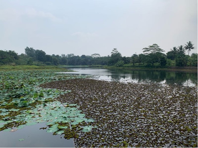
Figure 3. Situ Cigorongsong, Bogor Regency - where a lake's surface is covered with water plants

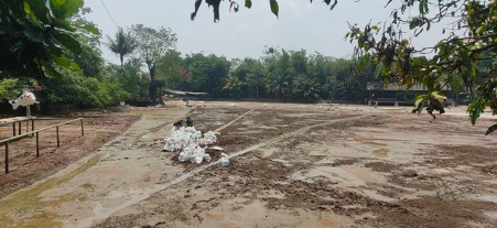
Figure 4. Situ Larangan, Bogor Regency - the lake is being dried for maintenance and regular cleaning by the community
In regard to their function, we discovered that a majority of these lakes still function to accommodate the daily needs of the local community, such as for fishing (38%), shops (27%), and recreation (20%), which signals they could be further optimized as flood mitigation infrastructure. Meanwhile, 14 lakes (8%) experienced a change in function, currently being used for gardens and rice fields, or have evaporated and been cleared for residential and commercial buildings. Gaining a better understanding of whether a lake remains as a body of water with its environmental functions or has been altered into dry land is imperative to determine an area’s adaptive capacity towards flooding.
With the dataset from this activity — which included photos and qualitative information on the lakes' surface condition and depth, their supporting features, and surrounding activities — we were able to support the government, helping them determine which lakes have manageable water flows and which ones need reinforcement. The mapping process also enabled the government to categorize lakes, making maintenance more efficient as part of an evidence-based policy-making process.
Additionally, through the help of Geospatial data, surveyors were able to verify the existence and locations of lakes. Prior to this activity, several lakes had been incorrectly mapped, being drawn as far as several hundred meters from their actual coordinates. This is an important result of the mapping process, as information on the map is critical in determining whether or not a lake can function as flood mitigation infrastructure, and any inaccuracies could be counterproductive to the cause.

City-level digital transformation and next steps
The map developed from this initiative contributes to the development of an integrated lake management protocol, that aims to guide the governance of natural and artificial lakes between central and regional governments. It also helps provide involved parties with an accurate analysis of the function of each lake, assisting them in determining whether a lake is used to mitigate flood, as a source of clean water, as a recreational area, and more.
Until now, the government had utilized a static map from 2019 as the basis for their protocols. Thus, this mapping initiative focused on utilizing open source and publicly accessible platforms to improve the quality of data used in the government, enhancing transparency and supporting digital transformation at the city level. The dynamic map provided the government with more comprehensive and higher quality data points that reflect conditions on the ground, making it easier to identify any potential opportunities and losses within the existing infrastructures. Additionally, thanks to the quality of this data, the map is able to assist the legislative process surrounding the issue more efficient as well as become a reliable reference for issuing lake maintenance permits.
During the project, the government invited several public sectors stakeholders, such as the Ministry of Public Works and the Audit Board of the Republic of Indonesia, to help them establish their plans for the development of the protocol, put together a scheme for future lake maintenance efforts, and propose an integrated framework of collaboration to support the documentation of these lakes as part of the national asset inventory.

To fully optimize the function of these lakes, a stronger and more coherent regulation system is needed, which the PMO Jabodetabekpunjur plans to address with a new lake management protocol in addition to a revised regulation on flood mitigation in 2024, which will be based on the updated database of mapped lakes.

 Locations