
 Locations
Data-driven Approach in Flood Mitigation: Collective Mapping Journey and Complex Systems
July 15, 2022

With Ajeng Larasati - Innovation Officer, UNDP Accelerator Lab Indonesia, Adhitya Dido - Communication & Community Engagement, Perkumpulan OpenStreetMap Indonesia.
Edited by Tomi Soetjipto and Ranjit Jose
Floods are one of the most common natural hazards. According to a recent study, an estimated 1.47 billion people globally are exposed to its substantial risks. Majority of the at-risk population live in low- and middle-income countries. Indonesia has the third highest absolute population exposure to flood risk, where 76 million people or 27 percent of its population are prone to flooding. UNDP is currently working on addressing this issue through the development of a portfolio of interventions, starting with a research on bottom-up and participatory approaches in flood mitigation, that showcases vast potential to involve citizens in optimizing sociocultural capital, local solutions and nature-based infrastructure in the process.
The densely populated capital and its satellite cities, collectively called Jabodetabekpunjur, experienced flooding regularly, which has displaced tens of thousands of people every year. While the government has invested in infrastructure including providing water pumps and conducting large drains, flooding remains prevalent. Lack of efficient drainage is responsible for much of the flooding issues. In order to strengthen a coordinated flood mitigation effort, a Presidential Regulation was passed in 2020 highlighting the need to improve the conditions and functions of natural and artificial lakes throughout the Jabodetabekpunjur area.
These lakes play a vital role in reducing floods through its storage capacity, whereas any area shrinkage or loss can amplify the damage for nearby communities. Initial restoration efforts identified a wide range of interconnected elements that contributed to the lakes’ functions - such as land disputes, urban sprawling, sedimentation, and physical alterations - exhibiting a far more complex system than anticipated. It is estimated that the area loss of lakes in Jabodetabekpunjur could cost IDR 250 billion (USD 17 million) in damages annually. Thus, increasing and maintaining the lakes’ conditions is a priority for the local government.
Mapping and Learning Collectively
To identify the flood mitigation potential from these lakes, an updated dataset was needed to measure recent changes in conditions and functions. With over 200 natural and artificial lakes within the Jabodetabekpunjur area, the UNDP Accelerator Lab Indonesia, together with the National Land Agency’s project office (PMO Jabodetabekpunjur) and OpenStreetMap (OSM) Indonesia Association sets out to collect data and increase the quality of information on these lakes through collective mapping.
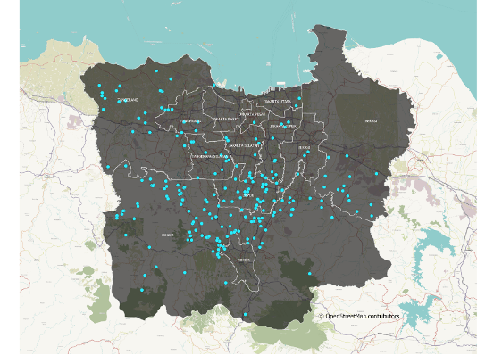
Figure 2. Distribution of artificial and natural lakes within different zoning areas.
During the planning phase, the Lab optimized its function as a global learning network by gaining insights from other Labs’ experience. In particular, we drew lessons from the Ukraine Accelerator Lab which conducted 'Digital Cherkasy', an interactive event that encourages citizens to map their city as an initial step towards inclusive development. We adapted it with a specific focus on developing geospatial data and combining it with survey insights to better understand the lakes’ changing dynamics and different needs of nearby communities.
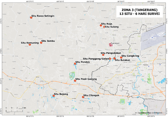
Figure 3. Example of a Survey Map in Zone 3, Tangerang
Communities as Agents of Change
Through this initiative, we are emphasizing the role of communities as possessors of knowledge - who have a better understanding of the conditions and issues surrounding the natural and artificial lakes. Local surveyors were recruited from nearby locations of the lakes to ease data collection and gathered responses from communities. These surveyors also participated in a capacity building session that focuses on technical skills for the mapping process.
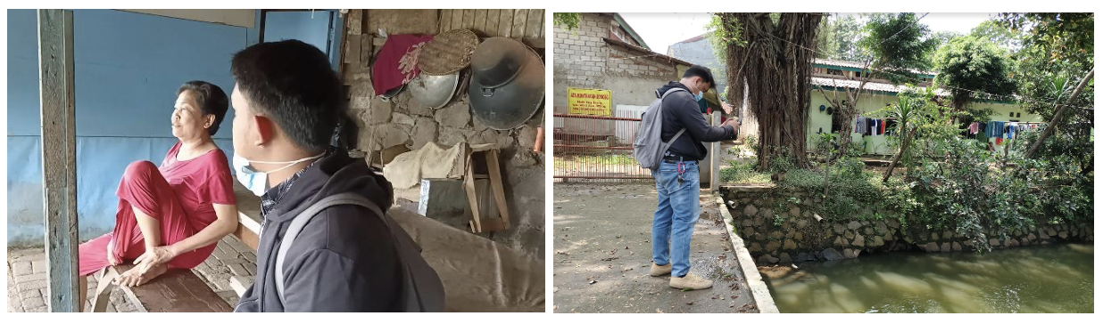
Figure 4. General overview of field survey process in Pamulang Lake, South Tangerang. Left: Surveyor interviewed nearby communities. Right: Documenting current condition of the lakes.
Improving the existing datasets on natural and artificial lakes with a local context will help planners identify better interventions, which could potentially involve citizens.
As women are disproportionately affected by disasters - including floods - moving forward, it is crucial to ensure representation from ‘voices that are under the radar’ to develop effective solutions. Focusing on digital solutions, there is a wide array of examples where women-led teams are paving the way on innovative platforms for disaster mitigation. This collective mapping initiative also aims to identify gaps and opportunities for women in maintaining the lakes’ functions in the long run.
Collective Mapping Design and Initial Insights
At the outset, this collective mapping initiative seeks new ways of doing things for sustainable development, which represents Collective Intelligence (CI) in action - combining the capability of people, data and technologies to solve wicked problems. Through integrating multiple data sources, this CI approach has the potential to assist policy makers to visualize the dynamics of complex systems and uncover insights that have previously been hidden. Moreover, as the initiative aims to promote data empowerment at the local level, insights gathered from the communities will be disseminated back to them for decentralized decision making.
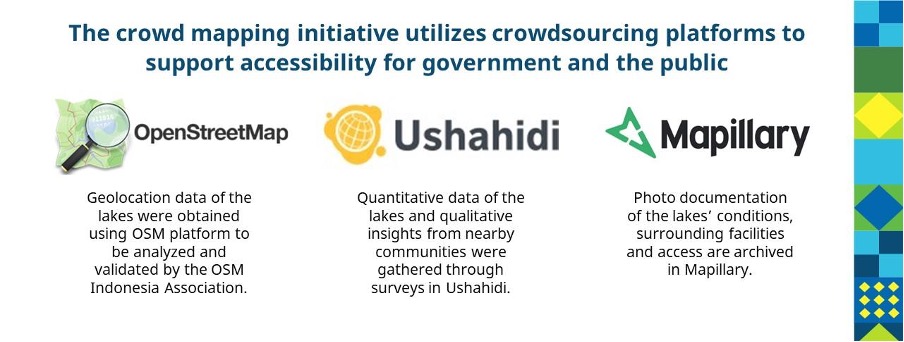
Figure 5. Various tools and data sources used in the Collective Mapping initiative
Combining the geospatial data element and localized survey insights can enable policy makers and urban planners to makes sense of the long-term patterns at the macroscale (i.e. impact of climate change and population increase towards lakes’ area shrinkage) and microtrends at the local level (i.e. the community’s changing relationship with these lakes). After the upcoming analysis, we expect to achieve spatial data from satellite imagery that is verified by findings on the ground. Other insights beyond spatial data would include issues that are related to future lake restoration programs such as documentation of the physical features available, environmental function mapping with a focus on flood risk reduction and identification of relevant stakeholders for lake management.
Several figures and preliminary insights from the early phase of the initiative:
- 170 natural and artificial lakes were mapped during a period of two weeks
- More than 50% of the lakes are in Bogor, known as the “Rain City”
- Several lakes were closely associated with local folklores and legends
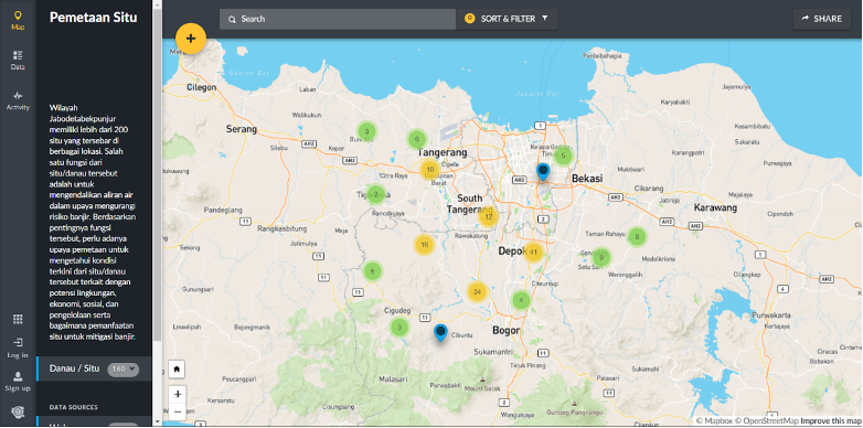
Figure 6. Initial outlook of the Ushahidi platform that captures survey insights
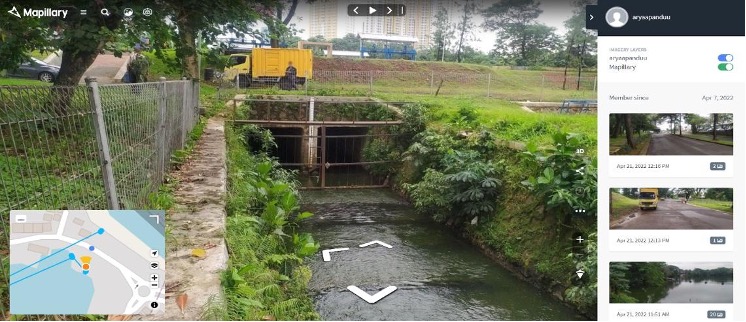
Figure 7. Usage of Mapillary platform to showcase water inlet and outlets in the lakes
Ripple Effect and Next Steps
The initiative kicked-off virtually in March 2022, to high enthusiasm from regional governments and the public, that demonstrated interest in follow-up training sessions. This ‘weak signal’ indicated a potential for further capacity building for mapping processes that leverages open access platforms. In the long run, similar initiatives could in turn contribute to the quality increase of data in the government and overall digital transformation at the city level.
Through this initial phase, UNDP Accelerator Lab with PMO Jabodetabekpunjur and OSM Indonesia Association have explored the numerous natural and artificial lakes in Jakarta and its satellite cities, investigating multiple data collection methods and crowdsource platforms in its journey. These findings bring about opportunities to learn further on the role of lakes as urban infrastructure to mitigate floods. Curious about other interesting insights along the journey? What are the key differences between the lakes in the existing database and the newly mapped ones? Stay tuned for part two of this blog!