Rangelands Defying the Odds: A Data Powered Positive Deviance Inquiry in Somalia
Rangelands Defying the Odds: A Data Powered Positive Deviance Inquiry in Somalia
April 12, 2021
Author: Hodan Abdullahi, Head of Exploration, UNDP Accelerator Lab Somalia, with Basma Albanna, Doctoral Researcher, University of Manchester, and Esther Barvels, GIS and Remote Sensing Specialist, GIZ.
Published by: Data Powered Positive Deviance DPPD.
The following piece was written by our partners from the Data Powered Positive Deviance DPPD initiative and was published on April 12, 2021.
The Data Powered Positive Deviance method acts as a kaleidoscope, refracting, combining,
and reflecting different perspectives and angles to identify and understand positively deviant communities. Photo by Lyle on Flicker
In every community, there are individuals or groups with uncommon behaviors who, while having access to similar resources, find better solutions to challenges than their peers. Finding these so-called positive deviants and promoting their solutions is referred to as the Positive Deviance approach. Building on this, the Data Powered Positive Deviance (DPPD) initiative combines traditional and non-traditional data to identify and understand positive deviance in new ways. As part of this initiative, the GIZ Data Lab, GIZ Project on Sustainable Land Management, UNDP Somalia Accelerator Lab, and the University of Manchester Centre for Digital Development are running a pilot in Somaliland to find positively deviant pastoral communities who managed to preserve their rangelands. This blog post provides a step-by-step presentation of the process undertaken to identify and validate those potential positive deviants.
DPPD Somalia Pilot
Pastoralists follow traditional livelihoods in the arid northern plains of Somalia. Livestock herding and agriculture are the basis of their livelihood, the national economy, and their culture. Economically, more than 80% of annual exports come from trade in livestock and livestock-based products. Culturally, pastoralists form the core population, and they are frequently highlighted in poetry and oral history.
Pastoral communities govern access to water and grazing resources through a mixture of institutions, rules, regulations, and informal tribal laws. However, pastoralists and their livelihoods suffer the burden of climate change. Cyclic droughts exhaust water and pastoral grazing resources, while population growth increases pressure on these resources. All this puts natural resources at the center of potential conflict and further instability. The need for the preservation of water and grazing resources is crucial, as they are key pillars of the region’s stability, culture, economy, and peoples’ livelihoods.
Rangeland management helps preserve grazing resources. It is a complex practice that considers dynamic and temporal factors. To understand the complex interactions within such coupled social-ecological systems, we need to account for various climatic, anthropogenic, and socio-economic factors. Understanding rangeland management requires the integration of larger structural factors and local practices that developed in their respective context.
In this pilot, we are looking for communities within Somaliland that have demonstrated enhanced rangeland health since the 2016–2017 drought. Our mission is to understand the underlying factors that helped them withstand the recurring droughts and the harsh drivers of rangeland degradation or desertification. The DPPD method will act as an analytical kaleidoscope, refracting, combining, and reflecting different perspectives and angles using different sources of data, eventually casting a spotlight on our model communities to highlight their practices and strategies for further inquiry. The pilot would be an alternative or complement to traditional development projects or initiatives. It would give us a more precise point of entry to design interventions or perpetuate existing ones, aimed at increasing the sustainability of rangelands and the resilience of local communities.
Pilot Design
To help design and frame the challenge, we conducted a series of stakeholder meetings. Stakeholders included representatives from the Ministry of Livestock and Fisheries, the Ministry of Agriculture, the Ministry of Environment, the University of Hargeisa, the Food and Nutrition Analysis Unit (FSNAU/FAO), and included two members of the agro-pastoral community in Somaliland. From these meetings, we reached a better understanding of the problem, the various drivers of rangeland degradation and preservation, and what could be considered a positive deviant community.
Selection of our Sample and Unit of Analysis
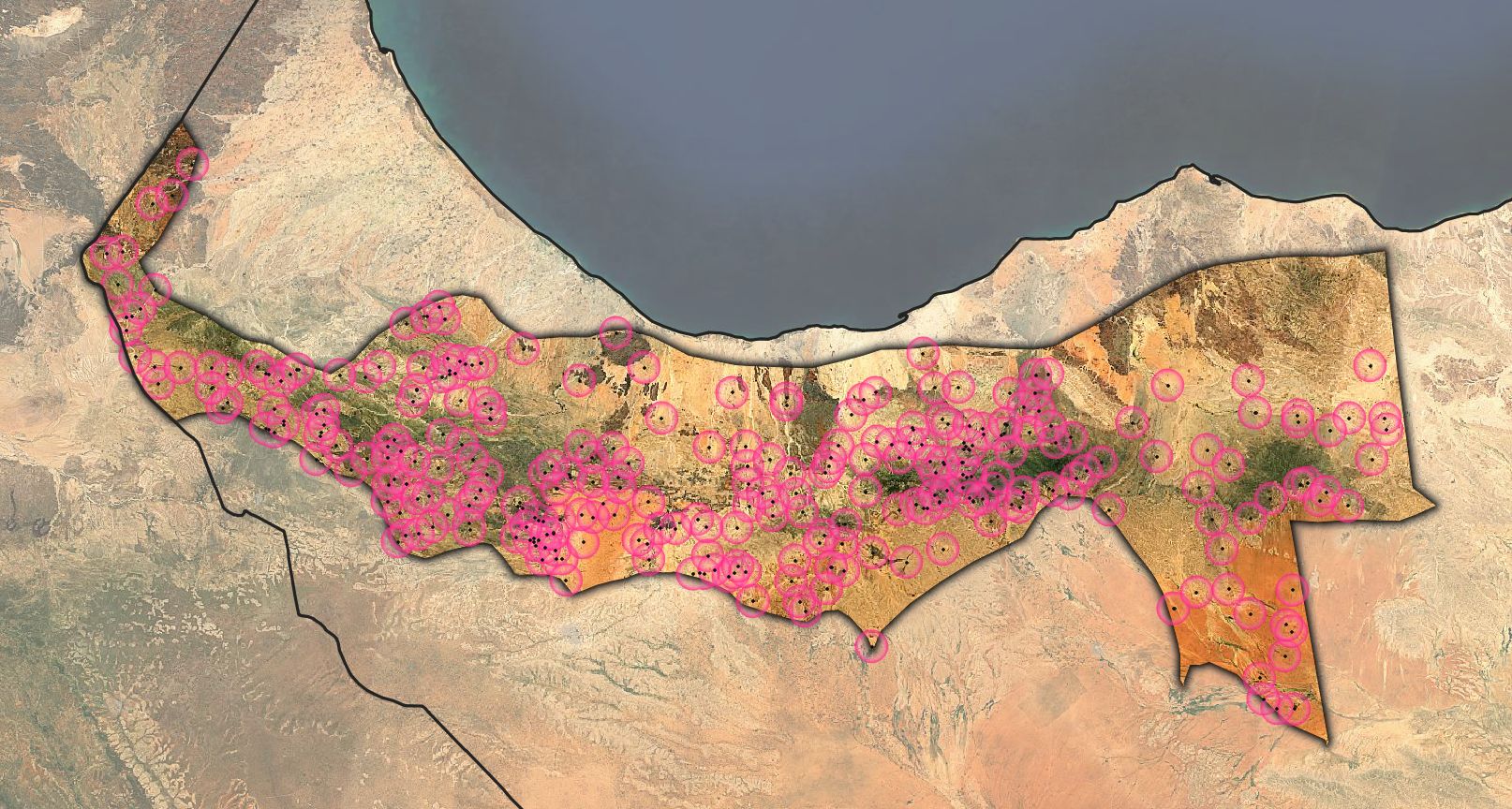
We chose the West Golis livelihood zone as our region of interest, which is defined by FSNAU as a zone with a majority pastoral community and relative ease of access. To analyze communities within this region, we accessed settlement point locations mapped from the World Bank data catalog overlaid on the region and found around 324 settlements.
We learned from stakeholders that communities dependent on livestock usually relied on the grazing resources around their settlements. Individuals walk 1–2 km with their animals (i.e., sheep and goats) to these grazing areas; for camels, the walk is around 6–10 km. We decided to use a 5 km buffer around these settlements to represent the average movement radius of livestock. We then merged the ones closest to each other (less than 2 km apart) because we can assume settlements this close will probably share their natural resources. This gave us a total of 261 out of 314 communities having distinct grazing areas or zones of influence.
Figure 1: Communities of 5 km buffer zones representing our unit of analysis within the West Golis livelihood zone.
Homogeneous Grouping
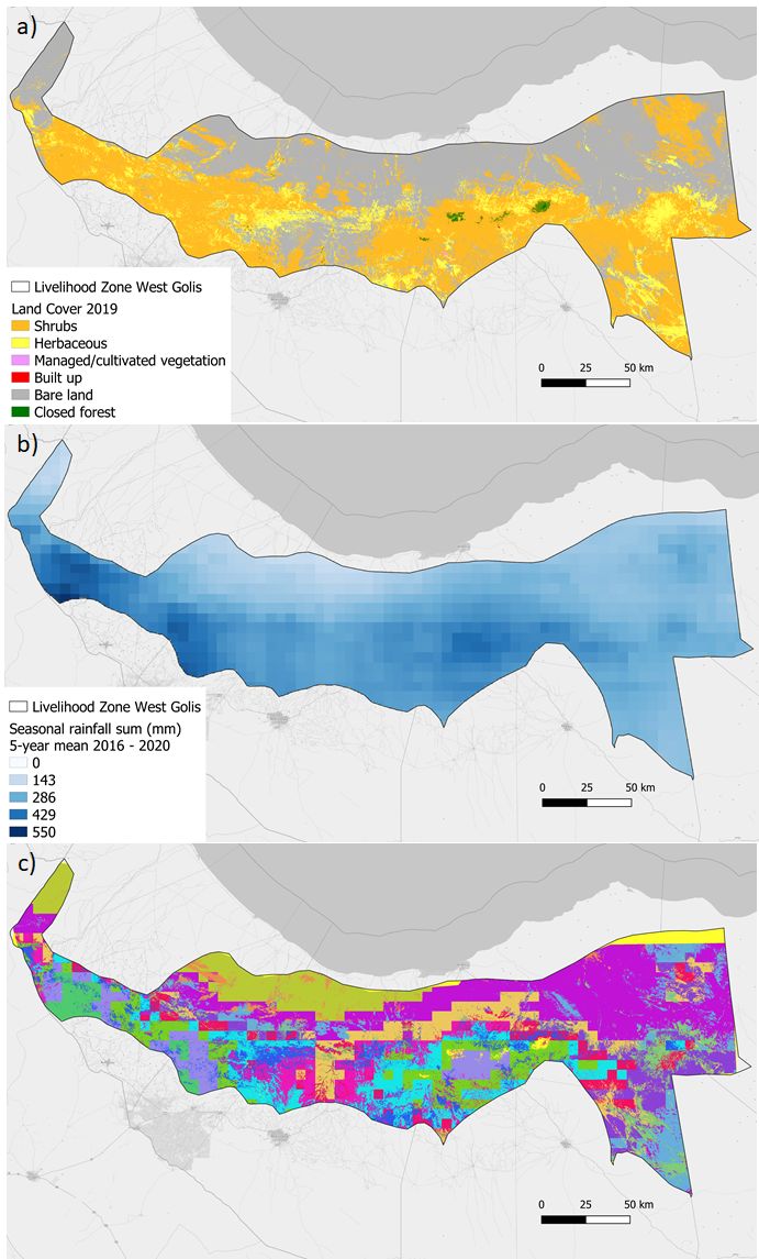
The West Golis pastoral zone covers the highlands of the Golis Mountain range and stretches over four administrative regions: Togdheer, Woqoyii Galbeed, western Awdal, and a small section of Sanaag. Within this region, we identified 261 zones of influence, and within them, an equally large structural diversity emerged. To capture and somewhat control for this biophysical and climatic variability, we needed to divide the geographical area covering those zones into homogeneous groups. We did this by identifying areas with similar land capability, or, in other words, groups with similar potential vegetation productivity, and grouped them together (Prince et al. 2009). This means that areas belonging to the same group, or homolog, would produce equally healthy rangelands in the absence of human land use, which will help us identify context-specific practices that are not separate from their localities. It will also ensure that the identified positive deviants in the communities are due to management practices and not due to biophysical and climatic factors such as heavier rain.
Variation in the potential vegetation productivity is caused by differences in land cover, land use, and climatic factors. Therefore, following Prince et al. (2009), we clustered our entire geographical region on a pixel-basis using an existing land cover data set from 2019 (Figure 2a) along with remote sensing daily rainfall data for the 5-year period from 2016–2020.
We calculated rainfall for every pixel (Figure 2b) using the mean of the rainfall sum of each growing season from April to November (start of the first rainy season, mid dry season, then consecutive rainy season) from 2016 until 2020. It must be noted that Somaliland and the greater Somalia have two rainy seasons: the main season, Gu, extends from April to July when 75% of rainfall occurs, and the season Dyer, when 25% of rainfall occurs, extends from September to November. Between these are two dry seasons: Hagaa (July to October) and Jillal (December to March), according to FSNAU. We then used k-means, a clustering technique, that resulted in 16 homologs with similar land cover and rainfall ranges (Figure 2c).
Figure 2: Homogeneous grouping. a) Land cover 2019, b) Mean seasonal rainfall sum for the period 2016–2020, c) 16 homologs resulting from clustering the rainfall and land cover data over the area of study.
Performance Measurement
One of the main challenges in this pilot was the choice of the performance measure. We asked ourselves what it meant to be a successful community in terms of livelihood or availability of natural resources. In an attempt to strike a balance between the two, we asked our stakeholders, “Are healthy rangelands a factor of success?” All stakeholders agreed that it indeed is desirable and identified the availability of animal fodder, animal health, open grazing fields, and the regeneration of deforested hot spots as indicators of this health. Agro-pastoralists added “grass that lasts until the next rainy season” as a signifier of health. In terms of livelihoods, we asked, “What does success mean for pastoralists and agro-pastoralists individually?” Here we found pastoral success was dependent on the quantity and welfare of livestock, while for agro-pastoralists success was dependent on maximizing crop yield and maintaining livestock quantity within a sustainable threshold.
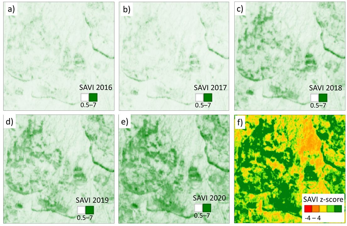
Based on this interdependent relationship between individual success in livelihoods and a more holistic rangeland health, we chose rangeland yield and regeneration as a representative measure of performance. To capture the rangeland performance of each community, we used the Soil-Adjusted Vegetation Index (SAVI), a remote sensing-based vegetation index that adjusts for effects of soil brightness, making it more suitable for arid regions such as the Somali rangelands where vegetative cover is low. To compute SAVI for each pixel, we used Sentinel-2 data with a spatial resolution of 10m².
Identification of Potential Positive Deviants
We previously defined positive deviants as individuals or communities who deviate in their outcomes from the standard within their local communities. Positive deviants in this pilot are communities that successfully maintained and enhanced the vegetation health of their rangelands compared to other communities suffering similar conditions.
To identify settlements with positive vegetation development, we applied a method called local scaling. This method measures vegetation condition by comparing it with a reference value representing the state expected in the absence of extreme climate and human land use (Prince et al. 2009). In other words, without human intervention or extreme climate influence, there should be no deviation from that reference value. By following this method, we accounted for variations in vegetation productivity due to differing local conditions, because vegetation productivity is calculated relative to its potential maximum within each homogeneous group.
We started by calculating the SAVI sum per season (actual SAVI) for the period 2016–2020 for each pixel (Figure 3a-e). Based on this, for each homolog we extracted the potential SAVI (maximum SAVI) per season using the 90th percentile — this value was assigned to all pixels belonging to the same homolog. The next step was to calculate the difference for every pixel between the actual SAVI and the potential SAVI. By doing this for all five years (2016–2020), we computed a linear slope of difference representing the temporal development of the pixel vegetation productivity in relation to its homolog potential SAVI. We then computed z-scores for those pixel slopes, a measure to standardize slopes in the same homolog. Values above 0 indicated positive SAVI development, and values below 0 indicated land degradation (Figure 3f).
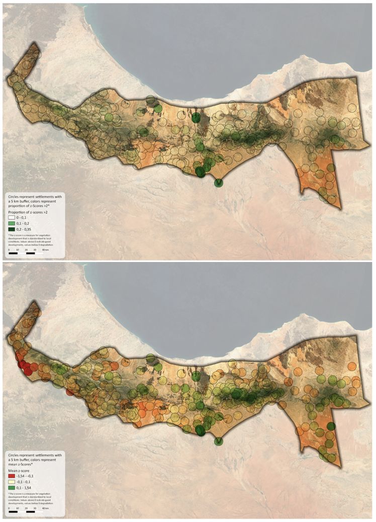
To identify our potential positive deviants, communities were ranked based on two criteria: the average z-scores of pixels within the community’s buffer zones and the proportion of pixels within those buffer zones having z-scores greater than two. Figure 4 presents the resulting community scores based on both criteria. A total of 13 communities were featured as top 10 according to the two criteria, and they were considered our first list of potential positive deviants.
Figure 4: (Top) Proportion of high z-scores > 2. (Bottom) Mean z-scores of our units of analysis within the West Golis livelihood zone.
Validation of Potential Positive Deviants
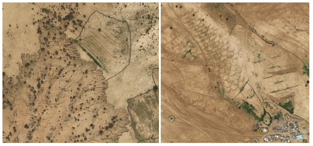
To select our final sample for the fieldwork stage of the pilot, we designed two stages of validation. The first is data-driven, where we used high-resolution satellite imagery to visually inspect the potential positively deviant communities in search of signs of pastoral and agro-pastoral activities, visible soil and conservation techniques, and other rangeland management practices. We also overlaid elevation maps, land-use systems, and strategic water surface maps to make sure, for instance, that pastoralism was the predominant activity in those communities and that the high biomass was not due to structural factors such as proximity to water points or due to geomorphological factors. Through this remote inspection, we identified patterns indicating the existence of soil and water conservation techniques at a number of potential positively deviant communities. Figure 5 presents some of those interventions.
Figure 5: Examples of soil and water conservation techniques. On the left, there is a shrub barrier in the frontline with soil erosion to limit its crawling. On the right, half-moon techniques to reduce water run-off.
In a second stage, we will present these potential positive deviants to stakeholders from the ministries, FAO, local NGOs, and others with knowledge of the communities to validate if the positive deviants could lead us to interesting practices and strategies or if they were falsely chosen due to known structural (non-transferable) factors that are driving the high SAVI scores.
What’s Next?
The pilot is an ongoing experiment. However, from our first line of validation, the existence of small-scale rangeland rehabilitation activities was evident, and a lot of questions were raised. For instance, if land enclosures or on the ground practices are a good thing or not, if they accelerate deterioration, or if they are the first line of rangeland regeneration. This would be revealed in detail in the fieldwork data collection stage — we will conduct a series of interviews and community discussions to discover the intricacy of what lies on the ground, find the individual or community efforts that cannot be observed from either data or stakeholder validations, and help us shed light on these practices and what makes them positive deviants or not. Eventually, this will help us find a mix of practices and strategies that show a huge impact on rangeland and if the exact opposite is true — how much the changing conditions affect the practices.
In our field investigation, we will embrace the complex dimensions of the problem at hand and look at it from a system-thinking lens, the same way a dynamic system in motion is viewed with inputs and outputs and overall behaviors resulting. Instead of looking at the potential positive deviants as points in isolation of the larger system, we will explore them as a system behavior (a mix of natural resources, livelihoods, and community or individual practices in balance with normal climatic conditions) and not as an individual behavior. If we look at extreme weather incidents, in this case, droughts, as a perturbation to the overall system from its balance, can we find a way (a mix of interventions, government policies, conservation efforts, new livelihoods, or awareness) to push these systems to find a stable fixed point again, moving it back into a balanced state? What is our point of action then, and what can we discover? All these questions and more will be answered in our next blog.
With special thanks to Andreas Gluecker, Project Manager, GIZ Data Lab, and Gunnar Hesch, Advisor for geospatial technology, GIZ, for their insightful comments and contributions.
About
The Data Powered Positive Deviance initiative was established on the belief that lessons on how to tackle complex sustainable development challenges are best learned from the people who face those challenges every day. It is with this mindset that the GIZ Data Lab, the University of Manchester Centre for Digital Development, and the UNDP Accelerator Labs are conducting a series of pilots in different countries and domains to uncover effective, locally developed practices and innovations as a response to development challenges.

 Locations