
 Locations
Prototyping a community-based emergency plan for floods
How is the “Little Girl” Behaving?
June 7, 2023

The UNDP Accelerator Lab in Panama, as part of the Collective Intelligence for the Climate Crisis process conducted a series of ethnographic activities to prototype a human-centric early warning system for floodings in the metropolitan area of Panama City with the potential to be replicated or scaled in the country.
In 2017 the community living alongside the “La Gallinaza” creek lived the worst flooding to this date. They still remember exactly what they were doing on that rainy Sunday when the water started to rise and swept everything in its path. “Nobody knew where to go, who to call or what to do. The water started entering through the windows, so I jumped out of the back of the house, but then I had water up to my waist and didn’t know where to go” shares Carlos, 21 years old, as his mom laughs about how he left her behind that day. This is one of many stories that have been shared by residents of Juan Diaz.
In our journey to understanding the systemic issues of urban floods and how they are affecting communities living in urban areas of Panama City, it has become clear that there is a huge disconnect between what communities face on the ground and how local authorities understand, prepare, and respond to their needs. Testimonies from residents have pointed out the need of a community-based reporting/warning system as well as an emergency plan. To test our hypothesis, we went to the field to answer this question: What data, information and functionalities should a prototype of an early warning system and preventative plan include for communities prone to flooding in the Juan Diaz River basin?
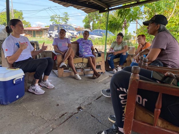
Figure 1 - Focus group at Luma’s house with residents of Juan Diaz that are continuously affected by the flooding of La Gallinaza
UNDP Panama Accelerator Lab
We met with nine community members at Luma’s house on a hot and sunny Friday morning. Luma Arellano is one of the oldest residents of this neighborhood, she has been living in her home that she now shares with her husband, daughter, son-in-law and five grandchildren, for over 40 years. One of the neighbors points at the creek that passes behind her home; “we used to jump over it and catch fish as they jumped. We even ate them, we made “cocinadito” (a sort of improvised barbecue using rocks) with plantain. Now it’s all contaminated”. As the conversation begins, they remember “La Paz” (“The Peace”), a small forest upstream that had a lake where they used to escape for a refreshing swim in the summer. “I came back home from work one day and they had cut everything, not a single tree was left. Not even that huge Panama tree.”
Urban floods are often associated to poor urban planning, where priority is given to concrete developments and little consideration taken for the natural ecosystems that surround them. The intensified contamination of rivers due to waste on a global scale is no exception here, with rivers transporting more than 102,229 tons of waste every year. The increase in the intensity of rain and rise of sea levels and tides in recent years has also changed the behavior of the creek. “Sometimes, not even 15 minutes go by and it [La Gallinaza] fills up and starts spilling into the streets and the houses, we have very little time to react” comments “Chiquillin”, father of 6.

Figure 2 - views of La Gallinaza during the community mapping of May 2023
UNDP Panama Accelerator Lab
Understand what works, and build from there
¿Como se está portando “La Niña”? (How is the “Little girl” behaving?). “We call it The Little Girl because it misbehaves and does what it wants”. The neighbors laugh. Understanding the type of information that is useful and what is needed is key to building our prototype. We start the workshop mapping the existing communication channels within the community, the type of information that is shared, and at which point of the event they share it. Although there are various existing informal communication systems, including WhatsApp, etc., – they depend largely on a few leaders, most of whom are those most affected by floods.
We have seen repeatedly how participants of these spaces tend to be mostly women, who, on a global scale, play a critical role in adapting to the impacts of climate change. To understand the dynamics of what happens in the homes and in the neighborhood when the flood starts, we asked the group to describe step-by-step the actions they take when they realize the water is starting to rise. This gave us an understanding of gender dynamics, where the women have roles of organizing the community and preparing the household, and the men of vigilantes watching up for the rise of creek. A gender- sensitive approach is essential to create an effective and inclusive prototype.

UNDP Panama Accelerator Lab
To test which elements an emergency plan should include, an exercise was carried out together with the neighbors to identify, by drawing on a map, the areas most prone to flooding, the possible evacuation routes, and the safe zones. This exercise allowed us to visualize and understand the dynamics between the territory and the different flows of water. It also permitted us to take into consideration the gaps of information and consensus regarding certain topics, such as which would be the right way to reach the “safe areas”.
After we finished drawing, we set out to walk to the places we had mapped, to visit and document the sites that had been pointed out and hear the stories of what had happened. But more specifically we also wanted to validate with the community which would be the exact spots and the kind of information that would be useful for them to receive or share in the case of an emergency. The more we walked, the better we understood the complexity of the territory, and how the history of its urban development had shaped the path of the creeks and redefined the living conditions of its residents throughout the years.
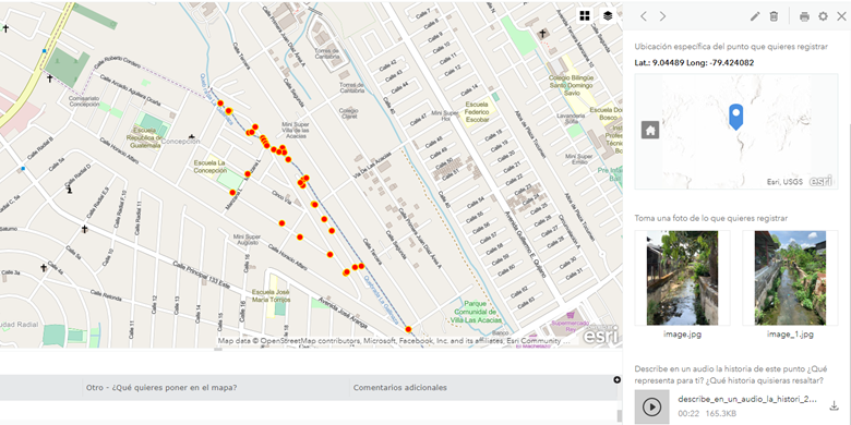
Figure 4 - map of points registered during the community mapping, which included critical flooding areas, safe locations and early warning systems (formal/informal)
UNDP Panama Accelerator Lab
“What is lost, is lost, my people and my dog is what matters, the rest, I’ll figure out later.” The unaccounted losses of the families affected by floods go beyond numbers. “We cannot tell you how many times we got flooded last rainy season, it’s easier to count the times that we didn’t get flooded.” For each flood, most households loose many of their belongings, such as fridges, furniture, electronic appliances, mattresses, and so on. We heard stories of a family having to change their fridge six times in a single year. Then there is the aftermath, having to clean, rebuild, restart, with very limited help from authorities. The repeated losses of assets and affectations to health creates a negative feedback loop that limits some community members to break the circle of poverty.
This focus group and community mapping in La Gallinaza builds on the collective intelligence process that seeks to co-design a community-led emergency plan and citizen-led reporting system that helps the dissemination of warnings and support the preventive measures to minimize affectations to floodings in Panama City. The Panama Accelerator Lab will continue to work with this community in the following months to iterate and refine the prototype.