
 Locations
Filling the Market with ‘Barrio’
March 13, 2023

The San Felipe Neri Public Market —el Neri— is part of the historic inner-city barrio of Santa Ana, about to turn 350 years old.
This barrio, one of the cradles of Panamanian democracy and, until recently, the center of Panama City’s commercial life, is undergoing profound changes —and el Neri is part of this complex territorial dynamic.
What relevance does el Neri have for its own barrio? And what does a circular economy have to do with this structural challenge? What can el Neri teach us about the public markets of the future?
These questions emerged from a workshop we held internally, with el Neri insiders, in which vendors and municipal officials alike shared their perception that el Neri is not frequented by the residents of its surrounding barrios.
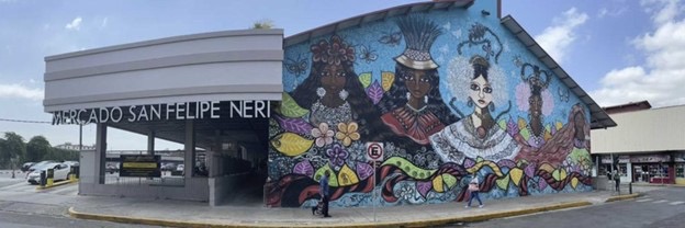
View of the San Felipe Neri Public Market.
Several hypotheses arose as to the reasons for this and, to test them, we went for a walk in Santa Ana with members of its different institutional and community groups.
The desk is a dangerous place to understand the world
“Who doesn’t live it, doesn’t get it”, said a market vendor. Thus, to understand el Neri’s environment, we went for a walk outside its market space, together with Panama City’s Public Markets Bureau, local institutions, and NGOs, in order to perform a community mapping process.
To carry out this mapping, we held a series of sessions to prepare and define what we were seeking to understand about el Neri’s environment, using geographic information system (GIS) tools to be able to visualize our findings on a map and discuss them as a group.

The thematic areas that emerged as input for the community mapping process (above) and workshop participants who defined the thematic areas to be mapped (below)

As a result, we set out to observe the commercial landscape surrounding the San Felipe Neri Public Market, the factors
that affect residents’ mobility and accessibility to it in Santa Ana, and this barrio’s waste situation, since the latter emerged as a critical problem affecting this area of Panama City.
How did we do it?
Five observation routes were established within a 300-meter radius of the market; during a workshop, participants were divided into five groups to map the five designated routes simultaneously.

The steps to perform our community mapping were simple: walk, observe, listen, take notes on paper, and record them using the Locus Map app for later validation, discussion, and analysis.

Mapping observation, annotation and registration process flowchart (left). All participants rehearsed this process together before going out to perform their tours (right).
What came out of this analysis?
During the six-hour community mapping walks by the five groups, 259 sites were registered and categorized as either facilitating or limiting access to el Neri.

Interactive map with our mapping results.
To navigate it, you may access it here.

Mapping participants’ observations and outcomes, regarding the sites they registered as limiting or facilitating access to the San Felipe Neri Public Market.
When categorizing mapping participants’ observations on the factors that either facilitate or limit access to el Neri, its surrounding commercial landscape ranked first as the main factor that influences neighboring communities to visit the market, mobility and physical access to it second, and the areas’ state of waste management third.
But what do these numbers mean? Later, while reflecting on our mapping exercise, we exchanged notes and thoughts on what participants had observed and how we had interpreted it.
Commercial landscape (34% of sites):
“You come out of your house, and you find a mini-market, or someone on the street sells you what you’re looking for right there.”
Mapping participants’ observations and outcomes, regarding the sites they registered as limiting or facilitating access to the San Felipe Neri Public Market.
During our community mapping walks, 86 points of sale were registered, encompassing restaurants, inns, grocery stores, supermarkets, and informal vendors, in contrast to the 50 commercial sites shown by OpenStreetMap, a free wiki world map.
The residential area of Santa Ana, which offers significant pedestrian mobility, not only includes informal vendors but also established supermarkets and grocery stores that sell similar products to those found in el Neri at a comparable price.
Mobility and physical access (32.8% of sites):
“The market’s surroundings aren’t inviting towards walking”, commented one mapping participant. Within the 259 sites recorded, barriers towards mobility included flowing sewage, open sewers, water meters without lids, sidewalks in poor condition and very few access ramps as their main mobility barriers.
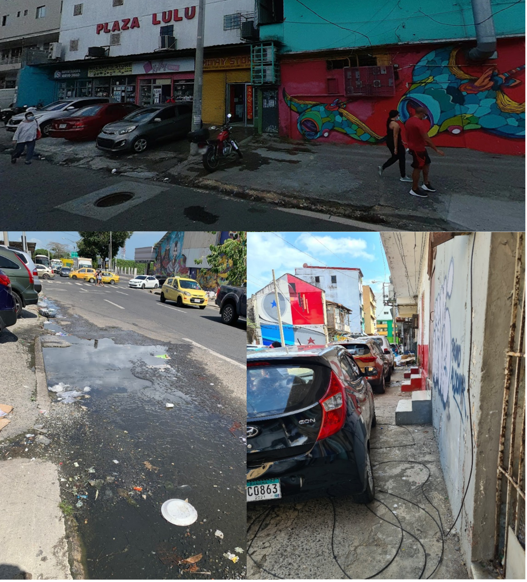
Cars overtaking sidewalks, flowing sewage, stuck sewers. This is the scenario that pedestrians must face in Santa Ana when trying to reach el Neri.
Regarding mobility, we learned that the mapped area has both high pedestrian and vehicular traffic. However, walking around el Neri is a monumental task; the very infrastructure meant to facilitate pedestrian mobility is considerably deteriorated.
The state of waste management (30.8% of sites):
“I know it’s a city problem, but I didn’t expect to see that amount of garbage on the street”, said one mapping participant. The element that mostly caught participants’ attention was the amount of waste overflowing into the streets.

The barrio of Santa Ana presents a critical waste management situation, with garbage taking over many of its sidewalks and streets.
Large amounts of waste —as well as vermin and foul odors— were found on every street. “It’s a state of abandonment”, said one participant. “When did we get used to living with so much trash?”, commented another.
The perspectives of mapping participants
After processing the data and information obtained, we held a second round of reflections on the results of our mapping, where each person shared their thoughts and perspectives on the process and what they had observed during their tours.
“A lot of people walk around [el Neri], but many people from San Felipe and Santa Ana have had to leave their barrios or have been evicted.”— Community mapping participant

Condemned and deteriorated buildings surrounding el Neri.
The populations of Santa Ana and San Felipe have decreased considerably in the last two decades due to gentrification, so there is less demand from the surrounding local population.
“Now there are other options, you go downstairs and there’s a store, there are new supermarkets and people prefer them, times have changed.” — Community mapping participant
Before conducting the mapping, participants saw informal vendors as one of the main reasons for poor sales at el Neri. However, through the process we observed that the offer from the surrounding barrio is vast and el Neri seems to have lost its relevance for today’s santaneros —the people of Santa Ana— when compared to newer options.
“The market was renovated and it’s pretty, but now it looks like a public market for another kind of people, not for the people who live nearby […] The market must recover its tradition and open up more to the barrio.” — Community mapping participant
The San Felipe Neri Public Market.
Could el Neri fill itself up once again with its barrio? How could it reconnect with Santa Ana and its people? And what does this teach us about the public markets of the future?
Learnings and recommendations for the public markets of the future
The San Felipe Neri Public Market, while remodeled, seems to have lost relevance both as a public market and a public space for the barrios that surround it.
- The public markets of the future must be designed with local people at their center, recognizing and integrating the history and sociocultural elements of each market’s community to preserve that market’s identity and relevance to its people over time.
- Community mapping exercises are a good starting point for the collaborative design of new public markets, amplifying community participation and opening the way to innovations based on residents’ creative visions, with a particular emphasis on those community voices that have not been heard.
- The use of GIS tools in community mapping processes facilitates the incorporation of community perspectives into architectural designs; they also provide valuable inputs for land-use planning.
- The San Felipe Neri Public Market encompasses a large area, which could be maximized to integrate and connect multiple community and cultural organizations within it, thus enabling these organizations to take advantage of el Neri’s space to develop new bonds and relationships with their communities.
Public markets are histories and cultures: their stalls and products encapsulate knowledge and practices that are part of our humanity. In contexts of poverty and inequality, public markets play a key role in providing nutritious food at affordable prices; however, their circularity will only be as relevant as they are able “to fill themselves with their barrios”.
In other words, their relevance depends on their capacity to integrate and invite those at their doors who do not feel welcome at the moment.
In our next blog, we will share the process of working together with more than 50 actors from Santa Ana to create a network of solutions regarding the circularity of the San Felipe Neri Public Market and the public markets of the future.
This blog is part of a series on learning activities and reflections generated by the UNDP Accelerator Labs, together with the Public Markets Bureau of the Municipality of Panama and the Panamanian non-profit Re-inventa, within the context of developing the Integrated Municipal Public Markets Network (RIMMU for its Spanish acronym). To learn more about our methodology and process, please feel free to read our full publication here.