
 Locations
What does space have to do with the transportation system and mobility in Chisinau?
Chisinau’s Data Collaborative: Moving with the Times
July 23, 2019


On an average day, a commute in Chisinau can be very difficult. On the road you may struggle with heavy traffic in key junctions on the city, or you may need to use one of the old public transport vehicles which slowly run on the cumbersome and unregulated traffic streets. The public transport stops locations and schedules have been set based on an assessment conducted some 30 years ago and has not been upgraded ever since. This is compounded by limited knowledge on how residents’ behaviors and habits have changed, and even less data on internal and external migration in the city. These challenges are not unique to Chisinau - increased migratory pressures towards urban centers, combined with deteriorating infrastructure, scarce information and limited resources of municipalities to respond to citizen demands and deal with complexity, are shared across the cities in Eastern Europe and Central Asia.
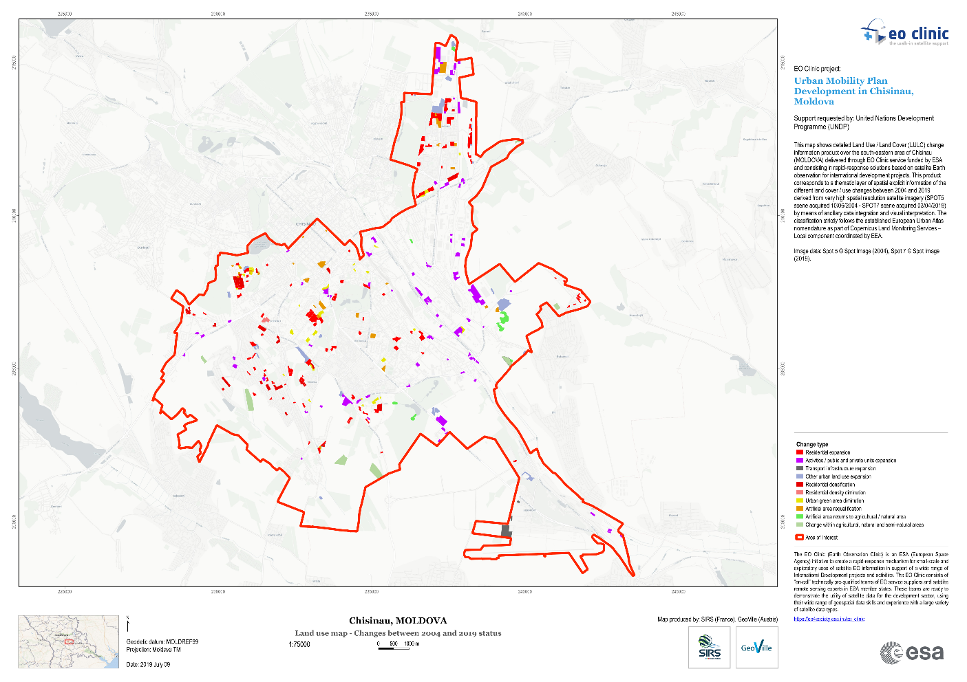
The Municipality is currently developing an Urban Mobility Plan, with the support of UNDP Moldova, in order to tackle the problems related to insufficient and inadequate public transportation and related infrastructure, impediments to urban mobility, safety, and planning. Facing a data blackout in Chisinau, together with the Municipality of Chisinau, we sought to explore how to understand people’s mobility behaviors and attitudes, and the changes over time, as well as look at patterns of urban development and mobility. To do so, we needed to move beyond traditional sources of data and partnerships: which is why we started working with Orange, Fenosa and the European Space Agency, and brought in our micro-narrative data - all in the service of making it easier, faster and more convenient for the residents of Chisinau to move around the city. Satellite imagery was used to map the city in a collaboration with the European Space Agency and their contractors GeoVille (Austria) and SIRS (France). Our area of interest is several large sectors/districts of the Chisinau city, to include Center, Botanica, Ciocana and so on.
In a nutshell, we want to assess and quantify the patterns and nature of urban expansion over time, identify where people live and how dense the city is populated using satellite Earth Observation and electricity consumption data. Further, we want to analyze the mobility behavior of people living in Chisinau and the extent to which the existing public transportation infrastructure is being used, as well as identify bottlenecks by using the mobile data from Orange. At the end of this process we will derive specific patterns of urban development and insights for several joint experiments. To make sense of the complexity of urban mobility and related behavior, we will also add another layer of thick data collected through micronarratives. Such data capture perceptions of people and is an optimal tool for collective intelligence and qualitative granular data. As an example: “... my commuting times are very long, too long for such a small city. Sometimes it is easier to walk if weather is good, `` said one of the respondents.
And our first results are in:
The first insights debunked our assumption about urban sprawl in Chisinau: since 2004 there has been no significant expansion of the built-up area in the studied area of Chisinau. Artificial areas increased by only 1% since 2004 up until now, at the expense of green spaces, which was against our understanding that the city was growing. Census data tell us the story of shrinking or stagnating city in terms of population. The population of Chisinau was in 2004 – 712,218 inhabitants, in 2014 – 550,685 inhabitants, and in 2018 – 572,115 people.
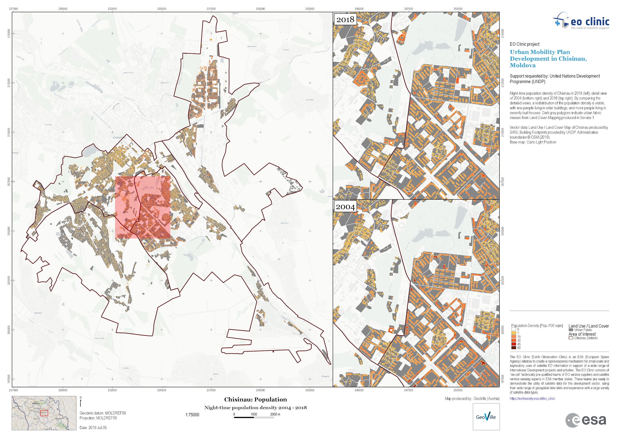
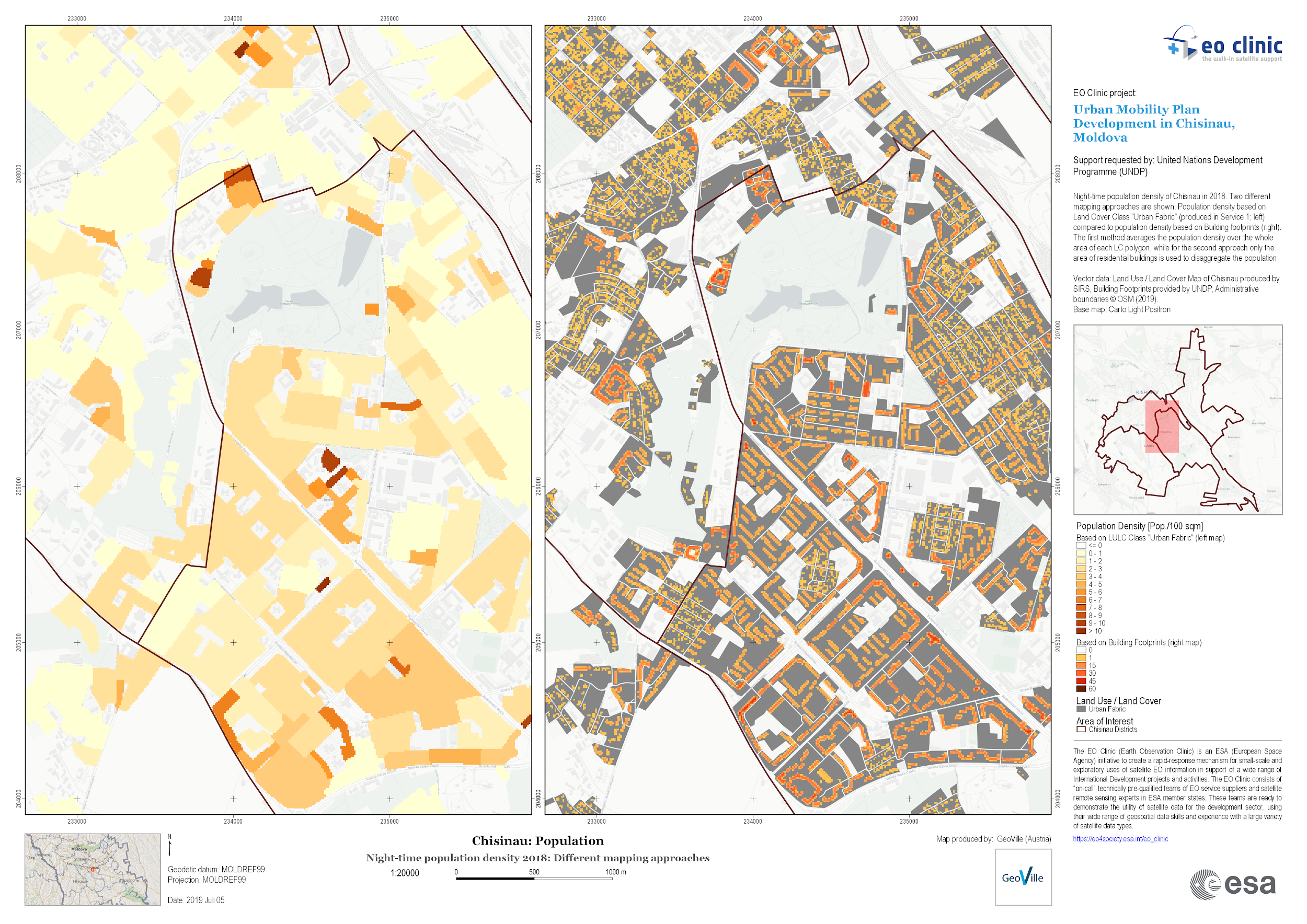
Residents of Chisinau are leaving older buildings and moving into newer built up residential areas. Now that we have density maps for Chisinau at night, identifying areas with high and low density we can start to analyze mobility patterns at daytime. More work is to be done to validate census data, we will be also looking into electricity consumption data and mobility, to understand that our estimations are reflecting the reality on the ground. This has heavy implications for urban planning as well
Urban mobility and its understanding through using big data is a new topic. For the first time we use telecom mobility data for Chisinau, and we want to derive mobility behavior and better understand how people commute within the city and what are the possible experiments. Moreover, we plan to conduct experiments to improve mobility behavior and overall mobility trends in the city. We want to experiment with the improvement of the network of public transportation and related infrastructure, by testing new improved positioning of the bus stations, itineraries and so on. Also, the multi-layering of data gives us great opportunity to understand existing or possible correlations between density, distribution and mobility trends, existing public infrastructure and services (hospitals for example) and mobility flows. We will also try to estimate some of the SDG indicators, as for instance Indicator 11.2.1 i.e. the proportion of population that has convenient access to public transport, by sex, age and persons with disabilities.
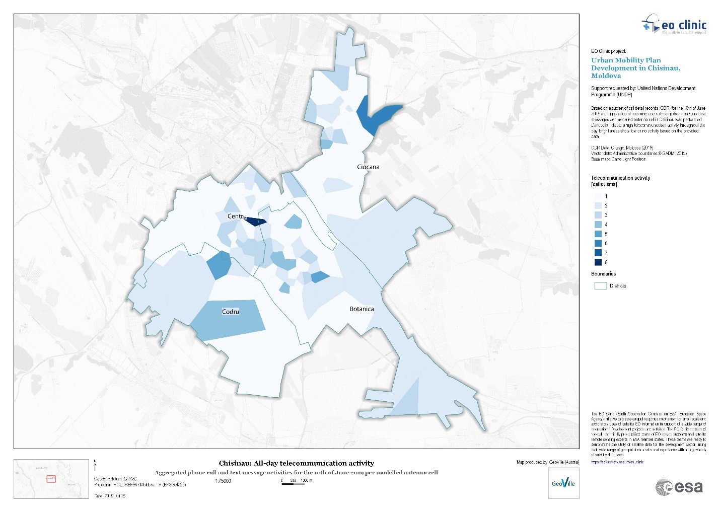
Now comes the most interesting and novel part. Using telecom data, for the first time in Moldova and Chisinau to understand, anticipate and plan mobility. First thing, we estimated telecommunication activity of people per district and modelled sub areas (via a Voronoi tessellation). Interestingly enough such analysis may be considered a proxy in estimating how busy certain areas in the city are during the day. The derived information can be used to adjust the current public transportation coverage to further target busy areas to increase the service degree.
Below picture depicts the aggregated activity of people throughout the day and highlights areas in the two busiest districts in Chisinau: “Centru” and “Botanica”.
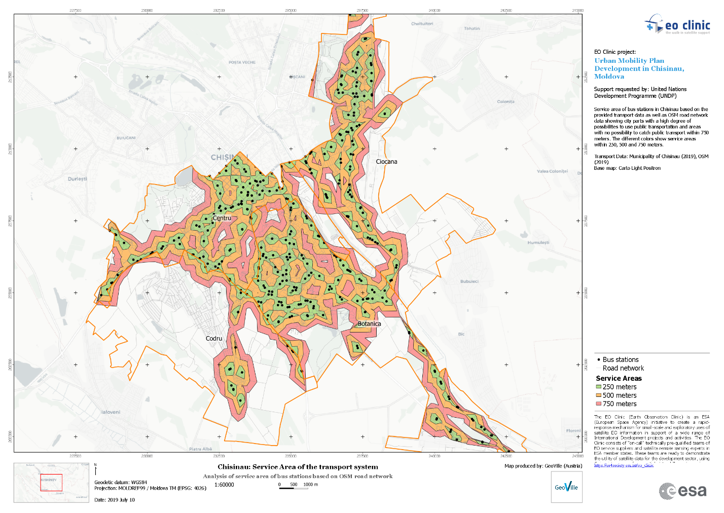
Our team’s main interest was to understand the degree of public transportation infrastructure availability for the population of Chisinau within the area of interest. Basis for the analysis was the walking distance to the bus stations of 250, 500 and 750 meters.
The results show the availability of bus stations within the selected area of interest. As shown on the map, in some city parts the availability of public transport is quite high, especially in the city center. But the analysis also shows that some parts, especially in the south-western area, are not at all connected to the public transport infrastructure (such as: public buses and trolleybuses). This distribution and coverage may be considered by local governance in planning new infrastructure. Our next step is to perform such a network analysis with various parameters, such as hospitals, schools, kindergartens, shops, playgrounds, etc.
These are some of the things we will be exploring in-depth in the next couple of days as we continue to work with our partners and collaborate with other cities in the region within the City Experiment Fund and other UNDP initiatives. Watch this space as we learn in real time about the forces shaping our cities.
Key contributors: Dumitru Vasilescu, Zoltan Bartalis, Lejla Sadiku, Bruno Goes, Christina Hirzinger, Maria Lemper, Aurelia Spataru.
Key partners: UNDP Moldova Innovation Lab, European Space Agency, Orange Moldova, City Hall of Chisinau, Green City Lab, GeoVille, SIRS, among many more partners.
All used data were fully anonymized and respecting the legal data protection procedures and legislation. UNDP Moldova is establishing a new evidence platform for engaging all relevant stakeholders in the generation and use of new evidence to generate insights and understand development patterns and then use the new evidence for experimentation work, i.e. generation and testing of safe-to-fail solutions to achieve SDGs at local level. Starting with the Municipality of Chișinău, the longer-term ambition is to connect other municipalities, smaller cities that could become poles of growth in the future (Cahul, Ungheni, Balti, Orhei and similar) as well as other partners and donors. New evidence, for example from Earth Observation data and geospatial information technologies, are expected to support promotion and accelerated achievement of the SDGs at local level as well as corporate citizenship and participation.
